




The Watcher: What is GISAT-1A?
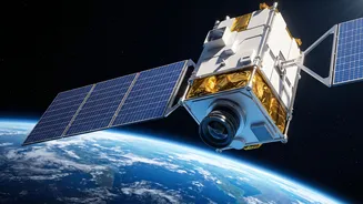
GISAT-1A, also known as EOS-05, is a state-of-the-art Earth observation satellite. Unlike most remote sensing satellites that orbit the Earth from pole to pole in a Low Earth Orbit, GISAT-1A is designed for a geostationary orbit. This means it will be
positioned approximately 36,000 kilometres above the Earth's surface and will move at the same speed as the Earth's rotation. The result is that the satellite will appear to remain stationary over the Indian subcontinent, allowing it to keep a constant watch. Its primary payload includes advanced imaging equipment that can capture pictures of the Indian mainland and surrounding oceans with high frequency. It's capable of imaging a selected area every five minutes and the entire country every half hour.
The Workhorse: Understanding the GSLV Rocket
The satellite will be carried to space by the Geosynchronous Satellite Launch Vehicle (GSLV). Specifically, this mission will use the GSLV Mk II version, a three-stage rocket standing nearly 50 metres tall. Its defining feature is the indigenously developed Cryogenic Upper Stage (CUS), which uses super-cooled liquid hydrogen and liquid oxygen as propellants. This cryogenic stage provides the immense thrust needed to push a heavy satellite like the 2,268 kg GISAT-1A into a highly elliptical Geosynchronous Transfer Orbit (GTO). From this initial orbit, the satellite will then use its own onboard thrusters to manoeuvre into its final circular geostationary slot. The GSLV is ISRO's designated vehicle for launching 2-tonne class satellites to GTO.
A Dual-Purpose Mission
The capabilities of GISAT-1A serve two critical national needs: disaster management and strategic surveillance. The satellite's ability to provide near real-time imagery will be a game-changer for monitoring rapidly evolving natural disasters like cyclones, floods, and forest fires. By providing continuous updates, it can significantly improve early warning systems and aid response efforts. On the strategic front, a constant eye over the region provides enhanced security and border monitoring capabilities. While it is a civilian satellite, its data can support the armed forces in planning and operations. Furthermore, its spectral imaging can be used for a variety of other applications, including monitoring agriculture, forestry, and oceanography.
A Story of Resilience
The September 4 launch is not just another mission; it's a story of perseverance for ISRO. This mission is a second attempt after the original GISAT-1 (also called EOS-03) was lost during its launch in August 2021. In that flight, the GSLV-F10 rocket's first two stages performed perfectly, but a technical anomaly prevented the crucial Cryogenic Upper Stage from igniting, causing the mission to fail. Since that setback, ISRO has meticulously worked to address the issue, and the GSLV Mk II has since recorded four consecutive successful flights. A successful launch of GISAT-1A would therefore not only deploy a vital national asset but also reaffirm the reliability of the GSLV launch vehicle, which is critical for future missions like the Gaganyaan human spaceflight programme.