






An Alarming Signal
On the morning of August 26, 2026, alarm bells rang across seismology centres when a 5.2 magnitude seismic event was detected in the Himalayas, near the border of Nepal and China. Initial reports from the United States Geological Survey (USGS) classified
it as a magnitude 4.4 earthquake, about 66 kilometres north of Kathmandu. In a region acutely vulnerable to tectonic activity, the immediate conclusion for many residents and officials was that a powerful earthquake had struck, leading to immediate concern about widespread damage and aftershocks. The news was especially worrying given the area's history, including the devastating earthquakes that have struck the nation in the past.
Initial Confusion and Reassessment
Within hours, the narrative began to shift. While Nepalese officials initially commented that an earthquake was the likely trigger for the chaos that followed, scientists reviewing the data noticed peculiarities. The seismic signature—the specific pattern of waves recorded by seismometers—didn't perfectly match a typical tectonic earthquake. After further analysis of long-period seismic waves and newly available satellite imagery, the USGS revised its assessment dramatically. They updated the event's magnitude to 5.2 and, crucially, reclassified its cause. It was not an earthquake at all.
The Real Culprit: A Catastrophic Landslide
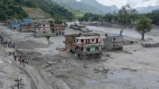
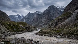
The 5.2 seismic signal was generated by a massive glacial collapse and subsequent landslide. An enormous mass of ice and rock broke free from a glacier high in the mountains, crashing down and creating a colossal debris flow. The sheer force of millions of tonnes of material moving at speed and impacting the ground generated seismic waves powerful enough to be detected hundreds of kilometres away, mimicking an earthquake. This catastrophic event blocked the Lhende Khola, a tributary of the Bhote Koshi river, triggering catastrophic flash floods that swept away villages, roads, and bridges in both Nepal and Tibet, killing at least 160 people and leaving hundreds missing.
How Can a Landslide Shake the Earth?
While it might seem surprising, massive landslides can and do register on seismographs. Unlike tectonic earthquakes, which are caused by the sudden slip of tectonic plates deep within the Earth's crust, landslide-induced seismic events are a surface phenomenon. The energy comes from the gravitational force pulling the mass downhill. The process generates seismic waves in several ways: the initial break of the rock and ice, the friction of debris grinding against the ground as it moves, and the final, violent impact as the mass comes to a halt. While the physics are different, the energy released into the ground can be equivalent to a moderate earthquake, as this tragic event clearly demonstrates.
A Sobering Reminder for the Himalayas
This disaster is a stark reminder of the complex and interconnected hazards facing the Himalayan region, an area highly sensitive to the impacts of climate change. Rising global temperatures are causing glaciers to melt and become unstable, increasing the frequency of events like glacial lake outburst floods (GLOFs) and massive landslides. The fact that this landslide was powerful enough to be initially mistaken for an earthquake highlights the immense scale of these dangers. For India and other neighbouring countries, it underscores the transnational nature of these threats, as rivers flowing from the Himalayas can carry the destructive force of such events far downstream. Improved monitoring that can distinguish between seismic signals from earthquakes and landslides is crucial for providing accurate and timely warnings to vulnerable communities.