




The New Golden Question
In Bengaluru's dynamic real estate market, priorities are shifting. Previously, homebuyers focused on amenities, builder reputation, and proximity to tech parks. Now, however, an increasing number of buyers are leading with a more critical question: "Does
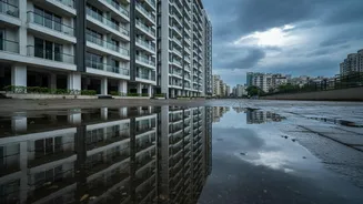
the area flood?" Unprecedented rainfall in recent years has caused widespread waterlogging, affecting even upscale neighbourhoods and so-called premium gated communities. This has forced both end-users and investors to look beyond the brochure and sunny-day site visits, making flood risk a decisive factor in property decisions.
Why Standard Research Isn't Enough
Bengaluru's rapid and often unplanned urban expansion has come at a cost. A study by the Indian Institute of Science found that a vast majority of flood-affected areas were built on what were once lake beds or natural stormwater channels, known as rajakaluves. Over the decades, the city’s interconnected valley and lake systems, which once managed monsoon flows naturally, have been severely encroached upon. This means that a property that looks perfectly safe in the dry season could be in a low-lying area or natural water path, making it vulnerable when the rains arrive. Consequently, price appreciation in high-risk zones has slowed significantly compared to safer areas.
Your Digital Investigation Toolkit
Before you even step out for a site visit, your research should begin online. Several resources can provide crucial clues about a property's flood risk. Start by checking the Bruhat Bengaluru Mahanagara Palike (BBMP) portal for its official list of flood-prone and low-lying areas. News archives are another invaluable resource; search for the locality's name along with terms like 'flooding', 'waterlogging', or 'monsoon' to find reports of past incidents. For a visual check, use Google Earth's historical imagery feature to see how the area has changed over time and if signs of water accumulation are visible in past years, particularly during monsoon months.
On-the-Ground Due Diligence
Digital research is essential, but it cannot replace physical verification. The best time to understand an area's water-related issues is during or just after a heavy spell of rain. However, since that is not always practical, the next best thing is to become a local detective. Visit the neighbourhood and speak to shopkeepers, residents, and security guards who have been there for years. They can offer firsthand accounts of past flooding that you won't find in any report. Look for physical evidence, such as water stains on the lower parts of compound walls or recently repaired ground-floor entrances, which can be tell-tale signs of previous waterlogging.
Decoding Maps and Legal Documents
For a deeper dive, consider consulting topographical maps, which show the natural elevation and slope of the land. This can help you understand if the property is in a natural depression or valley. When it comes to legal checks, go beyond the standard title verification. Insist that your lawyer scrutinises the property documents for any proximity to rajakaluve buffer zones. Experts suggest that comparing current layouts with historical maps, such as British-era survey maps from the 1880s, can reveal if the property sits on a former lake bed or drainage channel, which is a major red flag.
The Market Impact of Waterlogging
Ignoring flood risk can have significant financial consequences. While Bengaluru's overall property market continues to show resilience and growth, a clear divide is emerging. Localities with a history of frequent flooding have seen a drop in buyer inquiries and transactions, with some reports indicating a dip of 12-15%. In some cases, properties that were once valued highly have struggled to find buyers even at reduced prices after being affected by floods. For a homebuyer, this means not only the risk of damage and disruption but also a potentially poor return on a major life investment.