




Start with Real-Time Navigation Apps
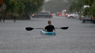
Your first and easiest check should be popular navigation applications like Google Maps and Waze. These platforms use crowd-sourced data to provide real-time updates on traffic jams, diversions, and road closures. During monsoons, they can be invaluable
for identifying waterlogged streets or accident sites. However, they have limitations. While excellent for city traffic, their information in remote or hilly areas might be less reliable. These apps are a great starting point, but they shouldn't be your only source, especially for long-distance trips or journeys into regions known for landslides. For highway-specific information, the Rajmargyatra app provides real-time updates on National Highways.
Consult Official Government Portals
For authoritative information, turn to government sources. The National Highways Authority of India (NHAI) and the Ministry of Road Transport and Highways (MoRTH) are responsible for maintaining the country's main road networks. The NHAI has an app, Rajmargyatra, and provides data to mapping services like Mappls on road work, accident-prone zones, and closures. The India Meteorological Department (IMD) is another crucial resource. Their website and social media channels issue regular bulletins on heavy rainfall, thunderstorms, and potential flooding, which directly impacts road safety. Checking the IMD's highway and tourism forecasts can help you anticipate weather-related disruptions.
Leverage the Power of Social Media
For the most immediate, on-the-ground updates, social media is an indispensable tool. Many state and city traffic police departments maintain active Twitter (now X) handles where they post real-time information about road blockages, diversions, and traffic flow. Search for the traffic police accounts of the areas you plan to travel through. Additionally, travel-focused Facebook groups and online forums can provide firsthand accounts from other travellers who have recently passed through the same routes. These communities often share photos and detailed descriptions of road conditions that you won't find on official channels, offering a realistic picture of what to expect.
Don't Underestimate Local Knowledge
Before you even begin your journey, pick up the phone. Contact your hotel, resort, or homestay at the destination and ask about the local road conditions. Staff and residents have the most accurate and current information about access roads and regional trouble spots that might not be reported by larger networks. They can tell you if a specific local bridge is flooded or if a minor road is affected by a landslide. This is especially important when travelling to hill stations or remote areas where the final stretch of the journey is often on smaller, state-maintained roads. This simple step can prevent you from arriving at your destination only to find the final leg of your journey is impassable.
Build a Multi-Source Checklist
Relying on a single source of information is a common mistake. The best approach is to cross-reference information from multiple platforms. A comprehensive check before leaving should include: reviewing your route on Google Maps or Waze for immediate traffic issues; checking the IMD website for weather warnings in your origin, destination, and transit regions; scanning the Twitter feeds of relevant traffic police departments; and calling your destination for local insights. This layered approach gives you a much more robust understanding of the potential challenges. If you see warnings about heavy rain from the IMD and reports of slow traffic on social media, you can make a more informed decision about whether to delay your trip or choose an alternative, safer route.