







The Anatomy of Urban Gridlock
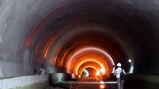
During a heavy monsoon spell, chaos on the roads isn’t just caused by rain; it’s caused by overwhelmed infrastructure. Our cities rely on a complex network of underground storm drains to carry away excess rainwater. However, these systems are often old,
clogged with silt and plastic waste, or simply not designed to handle the sheer volume of water from today’s intense, short-duration cloudbursts. When a critical drain gets blocked or exceeds its capacity, water has nowhere to go but up, spilling onto the streets. Within minutes, a key underpass or arterial road can become submerged, creating a bottleneck that paralyses traffic across a huge section of the city. The response is almost always reactive: by the time authorities are aware of the flooding, the damage is done and thousands of commuters are already stranded.
The Digital Watchdogs Beneath Our Streets
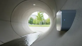
This is where the Internet of Things (IoT) comes in. Imagine small, rugged, waterproof sensors placed inside manholes and at critical junctions within the storm drain network. These are not just simple float switches; they are sophisticated monitoring devices. Many use radar-based technology to accurately measure the water level and flow rate within the drain in real time, without even touching the water. These sensors are designed to be self-sufficient, often powered by batteries with a lifespan of several years or even solar power. They act as digital watchdogs, constantly observing the city's hydraulic pulse, ready to report the first signs of trouble, 24/7, regardless of the weather conditions above.
From Raw Data to Actionable Intelligence
A sensor detecting a rising water level is only one part of the solution. The real power of an IoT-based system lies in its ability to communicate. Using wireless networks, these sensors transmit their data every few minutes to a central command centre. Here, a software platform visualises the information on a digital map of the city. Instead of seeing a collection of isolated data points, municipal engineers and disaster management officials see a complete picture of what is happening underground. The system can automatically flag anomalies. For example, if water levels are high in one manhole but low in the next one downstream, it's a clear indicator of a blockage between the two points. This transforms raw data into actionable intelligence.
Preventing Chaos Before It Starts
This real-time intelligence allows cities to shift from a reactive to a proactive flood management strategy. When the system predicts that a particular area is at high risk of flooding, a series of automated and manual actions can be triggered. Traffic police can be alerted to pre-emptively close off vulnerable underpasses and reroute vehicles away from the impending waterlogging, long before the first car gets stuck. Digital display boards on major roads can flash warnings, advising commuters to take alternative routes. At the same time, the system can pinpoint the exact location of a blockage, allowing municipal work crews to be dispatched with precision to clear the obstruction or deploy pumps where they are most needed. This prevents the initial flooding from escalating into widespread traffic chaos.
A Smarter Future for Indian Cities
This technology isn't science fiction; it's a key component of the 'smart city' vision being implemented across India. As part of the Smart Cities Mission, several municipalities are integrating IoT for better urban management. Cities are using this data not just for emergency response but for long-term planning, identifying recurring problem areas that need drain upgrades or redesign. By combining this 'grey' infrastructure data with green solutions like restored lakes and permeable pavements, urban planners can build more resilient cities. It represents a fundamental shift in managing our urban spaces, where data-driven decisions help maintain order and safety, even when the skies open up.