
A Groundbreaking Eye in the Sky
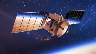
The NASA-ISRO Synthetic Aperture Radar (NISAR) mission is not just another satellite. Launched in July 2025, it is the most advanced Earth-observing radar satellite ever built, a testament to the powerful collaboration between the US and Indian space
agencies. NISAR is designed to monitor our planet’s surface in unprecedented detail, scanning nearly the entire globe every 12 days. Unlike optical satellites that are hindered by clouds or darkness, NISAR uses sophisticated radar to see through almost any condition, providing a consistent and reliable stream of information. Its purpose is to track some of the planet's most complex and subtle changes, from the slow creep of a tectonic plate to the shifting of an ice sheet.
The Power of Seeing Differently
At the heart of the mission is Synthetic Aperture Radar (SAR), a technology that sends microwave pulses to the Earth and interprets the returning echoes. This creates high-resolution, two-dimensional images that reveal the physical properties of the surface. What makes NISAR unique is its use of two different radar frequencies: L-band and S-band. The NASA-built L-band is excellent for studying forest structure and soil moisture, penetrating deeper into vegetation. The ISRO-built S-band is ideal for monitoring crop health and changes in surface vegetation. Together, they provide a comprehensive view that no single-frequency radar could achieve, detecting surface movements as small as a single centimetre.
From Data Points to Actionable Insights
The true value of NISAR lies in its applications, which are poised to revolutionise numerous fields. For disaster management, the ability to see through clouds and smoke will provide near real-time views of floods, earthquakes, and landslides, helping guide emergency response. In agriculture, farmers and policymakers will have access to high-resolution soil moisture maps, enabling better irrigation management and crop insurance programs. Scientists will gain invaluable data for tracking glacier melt, sea-level rise, and carbon stocks in forests, significantly boosting our understanding of climate change. For India specifically, the data will support critical initiatives in water resource planning, urban development, and geohazard assessment.
The 'Open Data' Revolution
Perhaps the most significant aspect of the NISAR mission is its commitment to open data. Following NASA's long-standing policy, all data from the mission will be free and publicly available. The first provisional L-band datasets were released in July 2026, accessible through NASA's portals, with ISRO providing access to S-band data via its Bhoonidhi hub. This democratisation of data follows the transformative path set by missions like Landsat, whose open archive in 2008 spurred a global boom in Earth science research and innovation. By removing financial barriers, NISAR empowers a global community of scientists, entrepreneurs, and public bodies to develop new applications and solutions to pressing challenges.
A New Era for Indian and Global Science
The release of NISAR's data adds serious momentum to the open Earth-observation movement. It represents a paradigm shift from a world where high-resolution radar data was the exclusive domain of well-funded government agencies. For India, the partnership is a landmark achievement, providing direct access to a torrent of information vital for national priorities, from Himalayan glacier monitoring to tracking agricultural biomass. Researchers across the country can now leverage this world-class data without restriction, fostering domestic innovation and scientific leadership. NISAR is more than a satellite; it is an enabling platform that will fuel discoveries and applications for years to come, demonstrating the power of international collaboration in tackling global challenges.