








Stronger Together: The Collaborative Frontier
No single agency, no matter how advanced, can tackle climate change alone. Recognizing this, NASA has intensified its strategy of joining forces with both international space agencies and domestic organizations. This collaborative approach is fundamental
to developing a holistic, 3D view of our planet, from the depths of the oceans to the highest layers of the atmosphere. By combining resources, expertise, and data, these partnerships enable more comprehensive and innovative research than would otherwise be possible. Projects like the Earth Information Center, a joint effort with other federal agencies, aim to put actionable climate data directly into the hands of decision-makers and the public.
An Eye in the Sky: The NISAR Mission
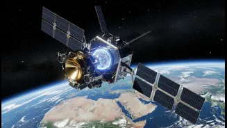
A prime example of this collaborative spirit is the NASA-ISRO Synthetic Aperture Radar (NISAR) mission, a landmark partnership between NASA and the Indian Space Research Organisation (ISRO). Launched in 2025, NISAR is the first satellite mission to use dual L-band and S-band radar frequencies, allowing it to measure changes in Earth's surface with unprecedented precision—down to less than a centimeter. This powerful tool will provide a time-lapse view of the planet, imaging the entire globe every 12 days. ISRO provided the satellite platform, the S-band radar, and the launch vehicle, while NASA contributed the L-band radar and a massive reflector antenna. This joint effort creates a satellite that is likely the world's most expensive Earth-imaging satellite, with a cost of around $1.5 billion.
What NISAR Means for India and the World
The data from NISAR—which is freely and openly available to the public—will revolutionize our understanding of some of the planet's most complex processes. For India, it offers a crucial tool for managing natural resources and hazards. The satellite will track changes in agricultural biomass, the extent of wetlands, and surface deformation that could warn of landslides or earthquakes. Globally, NISAR will monitor the dynamics of ice sheets and glaciers, providing vital information on sea-level rise. It will also track carbon storage in forests and soil moisture levels, key data points for climate modelers and policymakers working to mitigate climate change.
A Fleet of Partnerships
The NISAR mission, while significant, is just one piece of a larger puzzle. NASA's Earth Science Division has a long history of international collaboration. The recently launched Plankton, Aerosol, Cloud, ocean Ecosystem (PACE) mission will expand on a nearly 30-year record of observing ocean health, helping scientists understand how oceans and the atmosphere exchange carbon dioxide. Other significant collaborations include the Surface Water and Ocean Topography (SWOT) mission with the French space agency (CNES) and partners in Canada and the UK, which is surveying Earth's surface water in high definition for the first time. The 'A-Train' is a constellation of satellites from NASA and international partners that fly in formation, providing near-simultaneous observations of our planet.
The Future of Earth Observation
Looking ahead, NASA is planning the Earth System Observatory, a new generation of satellites designed to work together to provide a comprehensive view of the planet. These missions will focus on key areas identified by the scientific community, including aerosols, cloud dynamics, mass change in ice and water, and surface geology. This integrated approach, built on the foundation of open-source science and continued international collaboration, represents the future of Earth observation. By listening to and working with industry leaders, academic institutions, and international partners, NASA aims to deliver the science needed to inform critical decisions and help humanity respond to the challenges of our changing world.