








A Late-Night Spectacle with a Purpose
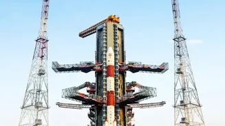
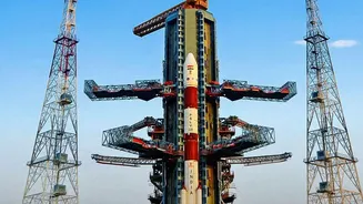
The Geosynchronous Satellite Launch Vehicle (GSLV-F18) is scheduled to lift off from the Satish Dhawan Space Centre, carrying the 2,250 kg NVS-03 satellite. After an 18-minute flight, the rocket will deploy the satellite into a Geosynchronous Transfer
Orbit (GTO). From there, a series of precise orbital manoeuvres will guide NVS-03 to its final destination, an orbital slot some 36,000 km above Earth. This launch is pivotal because it aims to restore and modernise the Navigation with Indian Constellation (NavIC) system, bringing the number of operational satellites back to the minimum of four required for providing positioning services.
The Heart of the Mission: An Indian Atomic Clock
At the core of the NVS-03 satellite lies a technological marvel: an indigenously developed Rubidium atomic clock. Atomic clocks provide the hyper-accurate timekeeping essential for any navigation system; even a tiny error of a few nanoseconds can throw off a position calculation by several metres. In the past, ISRO's first-generation navigation satellites relied on imported clocks, some of which failed prematurely, weakening the constellation. By successfully developing and deploying its own atomic clocks, ISRO takes a giant leap towards self-reliance, reducing dependence on foreign technology for such a critical strategic asset. NVS-03 carries this third homegrown atomic clock into orbit, a significant milestone for Indian space technology.
Why NavIC is India's Strategic Shield
NavIC is India’s independent regional navigation system, designed to provide accurate positioning and timing services over the country and a region extending 1,500 km beyond its borders. The push to create this system gained urgency after the 1999 Kargil War, when access to the American-owned GPS was reportedly restricted, highlighting the vulnerability of relying on foreign systems during conflicts. NavIC offers two services: a Standard Positioning Service (SPS) for civilian use and an encrypted, more accurate Restricted Service (RS) for military and strategic applications. An independent navigation system ensures that India's defence forces have guaranteed access to crucial location data for missile guidance, troop movement, and operating platforms, securing the nation's strategic autonomy.
Beyond Defence: Improving Everyday Life
While its strategic importance is paramount, NavIC's benefits extend to a wide array of civilian applications. These include disaster management, vehicle tracking, fleet management for logistics, and marine navigation for fishermen. The new NVS series of satellites, including NVS-03, are equipped with a new L1 frequency band, which is commonly used by commercial GPS receivers in smartphones and wearable devices. This integration will make it easier for NavIC to be adopted in the consumer market, potentially improving location accuracy in dense urban areas and remote regions where global systems might struggle. It will also help in establishing a robust Indian Standard Time (IST) system for critical infrastructure like banking and power grids.
The GSLV: A Trusted Launch Partner
The vehicle carrying this important payload is ISRO's GSLV, a threendstage rocket designed to place heavy satellites into high orbits. Standing over 51 metres tall, the GSLV uses a powerful cryogenic upper stage, a complex technology mastered by only a handful of nations. This will be the 20th flight for the GSLV, a rocket that has become a reliable workhorse for many of ISRO's most ambitious missions, including launching communication and navigation satellites that form the backbone of India's modern infrastructure.