







The Promise of a Watchful Eye
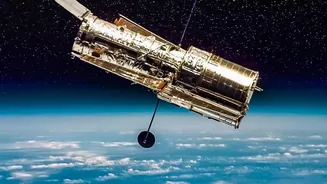
The EOS-05, also known as GISAT-1A, represented a major leap in India's space capabilities. Launched on September 4, 2026, its mission was ambitious: to become India's first imaging satellite in a geostationary orbit, approximately 36,000 kilometres above
the Earth. Unlike satellites in lower orbits that pass over a location periodically, a geostationary satellite remains fixed over the same region. This would have allowed EOS-05 to provide near-continuous observation of the Indian subcontinent. The plan was for the satellite to capture an image of a selected area every five minutes and the entire country every half hour. This capability was intended to be a game-changer for monitoring fast-moving natural disasters like cyclones and floods, tracking forest fires, and providing crucial data for agricultural planning and border surveillance.
A Tale of Two Launches
The successful launch of EOS-05 on the GSLV-F17 rocket was a significant moment for the Indian Space Research Organisation (ISRO). It came after a major setback in August 2021, when a nearly identical mission, EOS-03 (or GISAT-1), was lost due to a launch failure. In that instance, the cryogenic upper stage of the GSLV-F10 rocket failed to ignite because of a pressure leak in a fuel tank valve, preventing the satellite from reaching its orbit. The success of the EOS-05 mission demonstrated ISRO's resilience and its ability to overcome complex technical challenges, particularly with its indigenously developed cryogenic engine technology. This achievement not only placed a sophisticated 'eye in the sky' but also reinforced confidence in India's GSLV launch vehicle program.
India's Broader Constellation
While EOS-05 is a new, advanced asset, it joins one of the largest constellations of remote sensing satellites in the world, built by ISRO over decades. The Indian Remote Sensing (IRS) satellite program, which began in 1988, includes well-known series like Cartosat, Resourcesat, and Oceansat. These satellites operate in lower orbits and provide a wealth of data at different resolutions. The Cartosat series, for instance, is known for its high-resolution imagery used in detailed mapping and urban planning. The Resourcesat satellites focus on monitoring agriculture and natural resources, while the Oceansat series provides vital data for weather forecasting and marine studies. This diverse network of satellites ensures that even before the launch of EOS-05, India had robust capabilities for monitoring its land, water, and forests.
From Orbit to Farmland and Cities
The data from these satellites has tangible impacts on the ground. In agriculture, it is used for pre-harvest crop acreage and production estimation, monitoring drought conditions, and assessing soil health. This information helps in planning for food security and implementing schemes like the Pradhan Mantri Fasal Bima Yojana for crop insurance. For urban planners, satellite imagery is crucial for monitoring urban sprawl, planning new infrastructure, and managing land use. Furthermore, these satellites aid in mapping forest cover, locating underground water resources, and managing coastal zones, contributing directly to sustainable development and resource management across the nation.
A Critical Tool for Disaster Management
Perhaps one of the most critical applications of Earth observation data is in disaster management. Satellites provide indispensable support before, during, and after natural calamities. For cyclones, satellites like the INSAT series track their formation, intensity, and path, enabling timely warnings and evacuations. During major floods, satellite data is used to create inundation maps, which guide rescue and relief operations by showing which areas are worst affected. ISRO also provides regular updates on active forest fires to state governments and maps landslide-prone zones to mitigate risks. The near real-time capability of a satellite like EOS-05 is expected to significantly enhance these services, drastically reducing reaction times for fast-developing events.
The Future of Earth Observation
The successful deployment of EOS-05 is a stepping stone for ISRO's future ambitions. The agency is also collaborating with NASA on the NISAR (NASA-ISRO Synthetic Aperture Radar) mission, which will use dual-frequency radar to systematically map Earth and measure changes in its surface with incredible precision. This will provide data on everything from ecosystem health to groundwater levels and the melting of ice sheets. India also continues to develop its own missions, with plans for further satellites that will enhance its ability to monitor the planet. This ongoing investment ensures that space-based data will play an even larger role in India's development, security, and response to environmental challenges in the coming years.