






A New Eye on a Frozen World
Launched in 2025, the NASA-ISRO Synthetic Aperture Radar (NISAR) mission is one of the most sophisticated Earth-observing satellites ever built. It’s a testament to the powerful space partnership between the United States and India. Unlike typical satellites that
capture images using visible light, NISAR uses radar to map the planet. This technology allows it to see through clouds and operate day or night, which is essential for monitoring the perpetually dark and stormy polar regions. Its primary objective is to track subtle changes on the Earth's surface with unprecedented accuracy, from the rise and fall of land due to groundwater shifts to the slow creep of glaciers.
The Milestone Finding: Seeing Beneath the Ice
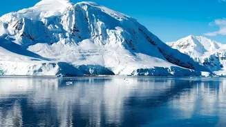
Recent data from Antarctica has highlighted exactly why NISAR is such a game-changer. The satellite has produced incredibly detailed maps of ice flow and structure, particularly around critical areas like the Thwaites Glacier. For the first time, scientists can precisely track the movement of grounding lines—the zone where a glacier lifts off the seabed and begins to float. This is a crucial area where warm ocean water attacks the ice from below, driving much of Antarctica's ice loss. While optical satellites see a mostly white, uniform surface, NISAR’s radar penetrates the top layers of snow and ice, revealing deep cracks, subglacial terrain, and the complex internal structure of the ice sheet. This provides a three-dimensional understanding of processes that were previously hidden from view.
The Power of Two Frequencies
NISAR's unique advantage comes from its dual-frequency radar system, a first for any satellite mission. It carries both an L-band radar, built by NASA, and an S-band radar, contributed by ISRO. These two different radar wavelengths interact with surfaces in complementary ways. The longer L-band waves can penetrate deeper, mapping the structure of the ice and the ground beneath, while the shorter S-band is more sensitive to surface properties like snow wetness and texture. By combining data from both, scientists can distinguish between surface melt and changes happening deep within the glacier. This ability to separate surface and subsurface phenomena provides a much clearer picture of what is driving ice loss and is a monumental leap forward from previous single-frequency missions.
A Proud Moment for India
ISRO’s contribution of the S-band radar is a cornerstone of the mission’s success. This collaboration places India at the forefront of global climate science and Earth observation. The data gathered by NISAR is not just vital for understanding polar ice; it will be used to monitor a wide range of phenomena critical to India, including Himalayan glacier health, agricultural land use, soil moisture, and landslide-prone areas. The open data policy of the mission means that Indian scientists and agencies will have free access to this firehose of information, empowering better resource management and disaster response across the country. The mission solidifies India’s role as a trusted partner in tackling the world's most pressing environmental challenges.
From the Poles to the Entire Planet
While the Antarctic findings are grabbing headlines, they are just the beginning. NISAR observes nearly all of Earth's land and ice surfaces every 12 days, creating a consistent, long-term record of our changing planet. Its ability to measure land deformation with centimetre-level accuracy will revolutionise our understanding of earthquakes and volcanic activity. In forestry, it will track deforestation and measure biomass with greater precision than ever before. For a world grappling with the impacts of climate change, from sea-level rise to food security, NISAR provides an indispensable tool. It moves beyond simply observing change to helping scientists understand the underlying processes driving it.