








The Constant Coastal Threat
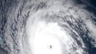
India's long and densely populated coastline is frequently in the path of tropical cyclones formed in the Bay of Bengal and the Arabian Sea. While high winds and torrential rain are dangerous, the greatest loss of life and property often comes from storm
surges—a massive rise in sea level caused by the cyclone's force. This wall of water can inundate low-lying areas in minutes, leaving little time for escape. Effective and timely evacuation is the only reliable defence, which makes the accuracy and lead time of warnings a matter of life and death. For decades, predicting the exact height and reach of these surges has been a complex challenge, one that ISRO is now tackling with renewed technological vigour.
A Sharper Eye in the Sky
The key to this enhanced capability lies in advanced radar technology, particularly Synthetic Aperture Radar (SAR). Unlike traditional optical satellites that are blinded by clouds, SAR can peer through them, as well as through rain and darkness. This all-weather, day-and-night capability is crucial for monitoring cyclones, which are, by their nature, shrouded in thick cloud cover. The recently launched NISAR (NASA-ISRO Synthetic Aperture Radar) mission is a prime example of this technological leap. As a joint project between ISRO and NASA, NISAR is the world's most expensive earth observation satellite, equipped with dual-band radar that can detect changes on the Earth's surface as small as a centimetre. By mapping coastal morphology and water levels with such high precision, authorities can generate far more accurate models of where a storm surge will strike and how severe it will be.
More Time, More Lives Saved
The practical impact of this upgrade is simple: more warning time. Advanced radar systems, combined with a network of Doppler Weather Radars on the ground, provide a more detailed and dynamic picture of a developing storm. Instead of just tracking a cyclone's path, meteorologists can now better analyse its structure, intensity, and the conditions that lead to devastating surges. This richer data allows for earlier and more reliable forecasts. An extra 12, 24, or even 36 hours of warning can make all the difference. It allows disaster management agencies to implement well-organized evacuation plans, move people to safer shelters, and position emergency response teams and supplies proactively. For residents, it provides the critical window needed to secure their homes, livestock, and most importantly, their families.
From Satellite to Citizen
This high-tech data doesn't stay in a lab. ISRO works as a crucial part of a national disaster management framework. Data from satellites like INSAT-3DR, Oceansat-3, and now NISAR is fed to the India Meteorological Department (IMD). The IMD uses this information to issue official cyclone and storm surge warnings. This information is then disseminated through a vast network that includes the National Disaster Management Authority (NDMA), state disaster response forces, and local authorities. Alerts are sent out via television, radio, SMS, and dedicated apps, ensuring the warning reaches even the most remote coastal villages. ISRO's Bhuvan and MOSDAC geo-portals also provide detailed, interactive maps to administrators for better decision-making.
Beyond Storm Surges
ISRO's commitment to coastal safety is broad. Recent initiatives like 'Project Bharati' use AI to analyse satellite imagery and live feeds to detect dangerous rip currents along beaches in real-time, with pilot projects already underway in Andhra Pradesh. This system can trigger automated sirens and alert lifeguards, preventing drowning incidents. This, along with its broader Disaster Management Support Programme, which provides data for floods, landslides, and forest fires, showcases ISRO's expansive role. The goal is to create a multi-layered technological safety net that uses space-based assets to protect Indian citizens from a wide range of natural hazards.