






India's Eyes in the Sky
The Indian Space Research Organisation (ISRO) operates one of the world's most sophisticated satellite-based disaster management systems. This network of Earth observation satellites is the backbone of the nation's strategy to mitigate the impact of natural
calamities. The Disaster Management Support (DMS) Programme comprehensively uses space-based technology to address disasters before, during, and after they strike. Key satellite series like the Indian National Satellite System (INSAT) and Radar Imaging Satellites (RISAT) play distinct but complementary roles. The INSAT series acts as a weather watch, constantly monitoring cloud cover, sea surface temperatures, and atmospheric conditions to forecast weather patterns. Meanwhile, the RISAT series provides a crucial all-weather, day-and-night viewing capability.
Predicting and Tracking Cyclones
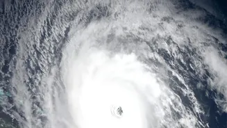
When a cyclone begins to form over the Bay of Bengal or the Arabian Sea, every hour of advance warning is critical. This is where ISRO's satellites provide the first line of defence. Satellites like the INSAT series (including INSAT-3D, 3DR, and 3DS) and Oceansat continuously monitor the oceans for signs of cyclogenesis—the birth of a cyclone. They track key variables like wind speed, cloud patterns, and storm evolution, feeding this data to the India Meteorological Department (IMD). This information allows meteorologists to predict a cyclone's intensity and track with increasing accuracy, enabling authorities to issue timely evacuation orders and prepare coastal communities, drastically reducing the potential loss of life.
Seeing Through The Clouds
One of the biggest challenges during peak monsoon is the thick cloud cover that renders traditional optical satellites blind. This is where the RISAT series becomes indispensable. These satellites are equipped with Synthetic Aperture Radar (SAR), a powerful microwave sensor that can penetrate clouds, haze, and darkness. When rivers overflow their banks or cyclones trigger widespread flooding, RISAT can provide a clear picture of the ground situation. The radar signals bounce off different surfaces in unique ways; smooth water surfaces appear dark in the resulting images, allowing analysts at ISRO's National Remote Sensing Centre (NRSC) to rapidly and accurately map the extent of flood inundation. This ability to generate near real-time flood maps is a game-changer for disaster response.
Guiding Relief and Assessing Damage
Once a disaster strikes, the focus shifts to rescue and relief. Satellite data is vital in this phase. The detailed, high-resolution flood inundation maps generated from RISAT and other satellites help the National Disaster Management Authority (NDMA) and State Disaster Response Forces identify the worst-affected areas. They can pinpoint marooned villages, submerged roads, and damaged infrastructure like bridges and railway lines. This allows authorities to plan rescue operations more effectively, directing boats and helicopters to where they are needed most. Furthermore, by comparing pre- and post-disaster imagery, officials can conduct a rapid and accurate assessment of the damage to crops, homes, and public utilities, which is crucial for planning long-term recovery and rehabilitation efforts.
Data for Everyone
A key aspect of India's satellite-driven disaster management is the dissemination of information. ISRO doesn't just collect data; it makes it accessible to various government departments and the public through powerful geoportal platforms. The most prominent among these is Bhuvan (Sanskrit for 'Earth'), which provides a wide range of services, including a dedicated disaster services mode. Another critical platform is the National Database for Emergency Management (NDEM), which serves as a national repository of geospatial data to aid decision-making. These portals provide near real-time information, allowing state and district-level officials to visualize the disaster's impact and coordinate response efforts efficiently.