





A Planet-Sized Data Problem
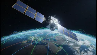
Every day, NASA’s fleet of Earth-observing satellites collects an astonishing amount of information. By 2024, the agency's archives were projected to hold around 250,000 terabytes of data, a figure that continues to grow exponentially. This treasure trove
contains critical insights into our planet's health, from sea level rise and deforestation to the extent of polar ice. The challenge, however, is immense: the sheer volume of data has outpaced the ability of scientists to manually analyze it. Finding meaningful patterns in petabytes of information is like trying to hear a whisper in a hurricane. This has created a bottleneck, slowing the pace of discovery at a time when understanding climate change is more urgent than ever.
Machine Learning: A New Lens for Earth
Enter machine learning (ML), a type of artificial intelligence that excels at identifying patterns in massive datasets. Instead of being explicitly programmed, ML algorithms learn from data, becoming more adept at tasks over time. For NASA, this technology is a game-changer. It allows scientists to automate the analysis of satellite imagery and sensor readings, uncovering connections that would be impossible for humans to detect. A key development has been the creation of 'foundation models' in partnership with companies like IBM. These are large, generalized AI models, trained on vast quantities of diverse Earth science data, which can then be adapted for specific tasks, acting like a Swiss Army knife for climate research.
AI in Action: From Floods to Forecasts
The applications of these new tools are already making a significant impact. One of the most prominent collaborations between NASA and IBM resulted in an open-source geospatial foundation model, named Prithvi (Sanskrit for Earth). This model has been fine-tuned to perform tasks such as identifying areas damaged by wildfires, mapping floodwaters, and classifying land use with remarkable speed and accuracy. For instance, researchers have used it to predict locust breeding grounds in Africa, a task they had long struggled with. Other AI models are being developed to improve the speed and accuracy of weather forecasts, predict extreme events like hurricanes, and even make satellites smarter by enabling them to autonomously decide where to focus their observations for the most valuable data.
Accelerating the Pace of Discovery
The primary benefit of integrating ML into climate research is speed. What once took scientists years can now be accomplished much faster, shrinking the time between data collection and scientific insight. For example, one weather and climate model demonstrated its power by accurately recreating a global temperature map from which 99% of the data had been removed. This ability to fill in gaps and make connections accelerates research and allows for more robust modeling. By making these powerful models open-source and available on platforms like Hugging Face, NASA and its partners are democratizing access to this data, allowing a global community of researchers to contribute to our understanding of the planet.
The Challenges and the Road Ahead
Despite its immense potential, the use of AI in climate science is not without challenges. These models require enormous amounts of computational power to train, raising concerns about their own energy consumption and environmental footprint. Furthermore, the quality of AI predictions is entirely dependent on the quality and diversity of the data it is trained on, and some models can operate as 'black boxes', making it difficult to understand exactly how they arrived at a conclusion. NASA scientists work to provide crucial expertise to guide the models, understand their strengths, and identify potential inaccuracies. The goal is not to replace human scientists, but to augment their capabilities with a powerful new generation of tools.