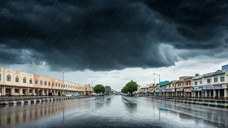


The Monsoon Makes a Belated, Intense Arrival
The India Meteorological Department (IMD) confirmed that the monsoon officially entered eastern Rajasthan on July 2, 2026, about seven days later than its typical onset date. While the rains are crucial for the state's agriculture and refilling its reservoirs,
this year's arrival is marked by forecasts of an exceptionally active and intense wet spell. The monsoon's northern limit is currently passing through key districts like Tonk, Jaipur, and Alwar, signalling its steady advance across the region. Forecasters have noted that conditions are favourable for the monsoon to cover the remaining parts of the state over the next few days, bringing widespread rainfall.
Which Cities and Regions Are on Alert?
The IMD has issued specific warnings for a large swath of eastern and southeastern Rajasthan. Divisions on high alert include Jaipur, Kota, Udaipur, Ajmer, and Bharatpur. The weather department has forecast spells of “heavy to very heavy rainfall,” with a warning for “extremely heavy rainfall” at isolated places, particularly within the Kota division. This puts districts such as Kota, Bundi, Baran, and Jhalawar at significant risk. Other areas expected to receive moderate to heavy showers accompanied by thunderstorms include Dausa, Chittorgarh, Banswara, and Pratapgarh. Even parts of western Rajasthan are expected to experience thunderstorms and dust storms.
What to Expect: More Than Just Rain
The current weather system is not just about downpours. The IMD has also warned of associated weather hazards, including strong thunderstorms and gusty winds that could reach speeds of 50-60 kmph. This combination increases the risk of disruptions. Potential impacts highlighted by authorities include waterlogging on roads in major cities, which can lead to significant traffic delays. There is also a risk of damage to vulnerable structures and kutcha roads, and the possibility of localized flooding. In hilly areas, the intense rainfall could trigger landslides or mudslips, posing a danger to residents and infrastructure.
How Authorities Are Preparing
State and district administrations have been gearing up for the monsoon's impact. Well in advance of the rains, the state government ordered disaster control rooms at both state and district levels to become operational 24/7 from June 15. The Disaster Management and Civil Defence department has focused on a coordinated plan to handle potential floods and waterlogging. This involves identifying vulnerable, flood-prone zones and ensuring that essential resources and response teams are ready for deployment. The emphasis is on preparedness and quick response to minimise loss of life and property, with all helpline services also functioning round-the-clock.
A Citizen’s Guide to Staying Safe
For residents in the alerted regions, staying informed and cautious is paramount. It is crucial to monitor official updates from the IMD and local authorities. Avoid travelling during periods of heavy rain unless absolutely necessary. Stay clear of waterlogged underpasses and low-lying areas, which can flood quickly and unpredictably. Secure any loose objects outside your home that could be affected by strong winds. Ensure you have an emergency kit with essentials like a torch, first-aid supplies, and adequate drinking water. Finally, stay away from weak structures, electric poles, and uprooted trees, and report any dangerous situations to the local disaster management control room.