


What is This Arabian Sea System?
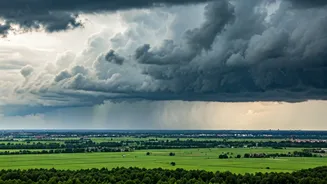
Meteorologists are tracking a well-marked low-pressure area, or in some cases a cyclonic circulation, brewing over the east-central Arabian Sea. Think of it as a giant, rotating column of air with lower atmospheric pressure at its centre. This low pressure acts
like a vacuum, pulling in moist air from its surroundings. While it may not be strong enough to be classified as a full-blown cyclone, its influence on the weather patterns over the subcontinent is substantial. These systems are common during the monsoon season and are critical for drawing the moisture-laden southwesterly winds onto the land, a process that is essential for widespread rainfall.
How It Steers the Rain
The monsoon doesn't just happen; it's guided. The monsoon trough, an elongated area of low pressure, typically runs from the northwest down to the Bay of Bengal. However, systems like the current one in the Arabian Sea can alter its behaviour. The powerful pull of this low-pressure area is effectively 'tugging' on the western end of the monsoon trough. This action invigorates the southwesterly winds, making them stronger and helping them push further inland. This system acts as a steering mechanism, directing a concentrated channel of moisture from the sea straight towards the coasts of Maharashtra and Gujarat, and then further into the central parts of the country.
The Forecast: A Path Across Central India
The primary beneficiaries—or recipients—of this guided rain front are the states in central India. The India Meteorological Department (IMD) has forecast that the system will move east-northeastwards. Initially, this means increased rainfall along the Konkan coast, including Mumbai, and parts of coastal Karnataka and Gujarat. As the system moves inland, it will bring moderate to heavy showers to large swathes of Maharashtra, especially the Vidarbha and Marathwada regions. Following that, its moisture will spread across Madhya Pradesh and Chhattisgarh, which have been anticipating a fresh spell of monsoon rains. This system is crucial for replenishing rainfall deficits that may have developed in these agricultural heartlands.
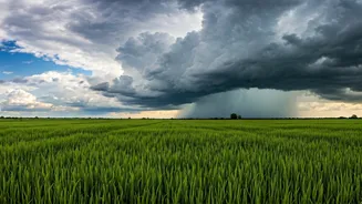
From Showers to Downpours
The intensity of the rainfall is expected to vary. Coastal areas could experience intermittent spells of heavy to very heavy rain, often accompanied by gusty winds. This could lead to familiar monsoon problems like waterlogging in low-lying urban areas and traffic disruptions. For inland regions in central India, the rainfall is likely to be more widespread but might range from moderate showers to isolated heavy spells. This is generally good news for agriculture, as it provides the sustained moisture needed for Kharif crops. However, the IMD has also issued warnings for fishermen, advising them not to venture into the rough seas of the east-central Arabian Sea where the system is most active.
Is This Normal for the Season?
Yes, the formation of such low-pressure systems in either the Arabian Sea or the Bay of Bengal is a textbook feature of the Indian Summer Monsoon. They are often called the 'engines' of the monsoon for good reason. Their frequency and intensity can determine whether a monsoon season is considered 'normal,' 'above-normal,' or 'deficient.' A series of well-spaced, moisture-pulling systems like this one often leads to a healthy distribution of rain. What makes each system unique is its specific track and intensity, which determines exactly which regions get drenched and which remain dry. Meteorologists monitor these systems closely, as their path can sometimes be erratic, requiring frequent updates to forecasts and advisories.