





What is Cyclone Akvan's Current Status?
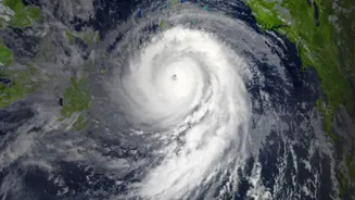
As of the morning of November 18, 2026, Cyclone Akvan is a Cyclonic Storm located over the Bay of Bengal, roughly 610 km south-southeast of Visakhapatnam, Andhra Pradesh. The India Meteorological Department (IMD) has been tracking its development from
a deep depression, which intensified into a cyclonic storm on November 16. The system has been moving very slowly, at speeds of around 3 kmph, which adds a layer of complexity to its forecast. The IMD expects it to strengthen into a Severe Cyclonic Storm during the day on November 18, and further intensify into a Very Severe Cyclonic Storm by the evening of November 19. Authorities have issued an 'orange' alert for the coasts of Andhra Pradesh and adjoining south Odisha.
Why Cyclone Forecasting Is So Challenging
Predicting the precise path of a cyclone is one of the toughest jobs in meteorology. A cyclone's movement is dictated by large-scale weather patterns, often called steering currents, which are themselves constantly shifting. Forecasters use multiple complex computer models, such as the European ECMWF and the American GFS, which can sometimes produce different results based on their initial data and calculations. The storm's own structure, especially when it's broad or disorganized, can also lead to erratic short-term motion. Furthermore, forecasters are generally better at predicting a cyclone's track than its intensity. Factors like sea surface temperature, wind shear (the change in wind speed and direction with height), and the amount of moisture in the atmosphere can cause a storm to strengthen or weaken rapidly, making forecasts a constant process of revision.
Decoding the 'Cone of Uncertainty'
You will often see cyclone forecasts presented with a 'cone of uncertainty'. It is crucial to understand what this means. The cone does not show the size of the storm. Instead, it represents the probable track of the storm's centre. Historically, the centre of the storm stays within this cone about two-thirds of the time. This means there is still a one-third chance the centre could track outside the cone. The cone widens over time, showing that the forecast becomes less certain the further into the future it goes. Importantly, a cyclone's impacts—like heavy rain, storm surge, and high winds—can extend hundreds of kilometres from its centre, far beyond the cone itself. Therefore, even if you are outside the cone, you could still be at risk.
The Latest IMD Landfall Forecast
According to the latest IMD bulletins, Cyclone Akvan is expected to make landfall around noon on November 20. The projected crossing point is along the Andhra Pradesh and Yanam coasts, somewhere between Nellore and Visakhapatnam. At the time of landfall, it is forecast to be a Very Severe Cyclonic Storm with maximum sustained wind speeds of 120-130 kmph, and gusts reaching up to 145 kmph. The IMD has issued explicit warnings for fishermen to stay out of the Bay of Bengal and for coastal residents to remain vigilant. Authorities in Andhra Pradesh and Odisha are preparing for the storm's impact, readying rescue teams and planning for potential evacuations.
How to Prepare Amidst Uncertainty
When a forecast is uncertain, the best response is to prepare for the most likely scenarios. The most important step is to monitor official information from the IMD and local disaster management agencies and ignore rumours. Prepare an emergency kit with essentials like non-perishable food, drinking water, a first-aid kit, medicines, a torch with extra batteries, and a power bank. Secure your home by boarding up windows if necessary and moving loose objects like flower pots and outdoor furniture inside. Keep important documents in a waterproof bag. Ensure your mobile phones are fully charged. Even if the storm changes track, being prepared is never a wasted effort.