






A New Kind of Eye in the Sky
EOS-05, also known as GISAT-1A, represents a significant leap in India's Earth observation capabilities. Unlike most imaging satellites that circle the Earth in low orbits and pass over a specific area only periodically, EOS-05 is designed for a geostationary
orbit. By positioning itself at an altitude of approximately 36,000 kilometres, the satellite’s orbital speed matches the Earth's rotation. This allows it to remain seemingly stationary over the Indian subcontinent, providing constant and uninterrupted surveillance of a large geographical area. This capability to offer near real-time imagery is what sets it apart and makes it a game-changer for a variety of national applications.
The Power of Persistent Monitoring
The primary advantage of a geostationary perch is the ability to watch events unfold. EOS-05 was engineered to image a selected area of interest every five minutes and the entire Indian landmass every half hour. This rapid revisit capability is invaluable for tracking the progress of dynamic events. For disaster management agencies, it means the ability to monitor the development of cyclones, the spread of forest fires, and the extent of flooding as they happen. For farmers and agricultural planners, it offers a way to assess crop health and environmental conditions over wide areas with unprecedented frequency. This flow of continuous data can lead to quicker, more informed decision-making during emergencies and better resource management.
A Tool for National Security
Beyond its civilian applications, the strategic importance of a satellite like EOS-05 is immense. The ability to provide persistent monitoring over borders and maritime regions offers a significant advantage for national security. While most Earth observation satellites in lower orbits provide snapshots in time, EOS-05's constant gaze would allow for the tracking of changes and movements in sensitive areas. This 'eye in the sky' can provide crucial data for security forces, helping to maintain vigilance over vast and often remote territories. The mission is intended for both civilian and strategic use, highlighting its dual-purpose role in serving the nation.
Redemption After a Setback
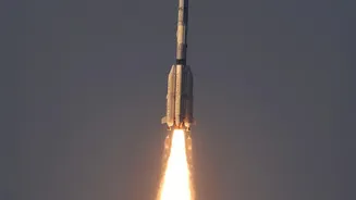
The journey of this technology has not been without challenges. The EOS-05 mission is particularly significant as it follows the loss of its predecessor, EOS-03 (also known as GISAT-1), in August 2021. That mission failed when the GSLV rocket's cryogenic upper stage did not ignite as planned, preventing the satellite from reaching orbit. An investigation pinpointed the cause as a pressure leak from a faulty valve. The successful launch of EOS-05 on September 4, 2026, aboard the GSLV-F17 rocket, therefore, marks a moment of redemption for ISRO, demonstrating its resilience and mastery over the complex cryogenic launch technology.
India's Vision From Orbit
With the successful deployment of EOS-05, India joins an elite group of nations with the capability to operate a geo-imaging satellite. This state-of-the-art spacecraft, weighing over 2,300 kg, is one of the heaviest payloads launched by the GSLV. Its advanced imagers can capture details across multiple spectral bands, providing rich data for environmental scientists, urban planners, and disaster relief coordinators. The mission is a testament to India's growing prowess in space, showcasing an ability to develop and deploy complex, high-value assets that directly contribute to national development and security. It reinforces ISRO's role as a creator of critical infrastructure for a modern, resilient India.