


Red and Orange Alerts Dominate The Region
Large parts of Northeast India are under high alert as the Southwest Monsoon intensifies. The IMD has issued a red alert for Assam's Kokrajhar and Chirang districts for June 28, indicating the highest level of warning. An orange alert, signifying a call
for preparedness, has been issued for Assam's Baksa, Lakhimpur, and Dhemaji districts. This pattern of heavy to very heavy rainfall is not confined to Assam. Widespread downpours are expected to continue across Arunachal Pradesh, Meghalaya, Nagaland, Manipur, Mizoram, and Tripura through the end of June and into early July. An IMD press release from June 27 specifically highlighted the likelihood of isolated extremely heavy rainfall over Assam and Meghalaya on June 28. These alerts warn of rainfall amounts that can exceed 204.5 mm in some areas, a volume that severely tests the region's infrastructure and natural drainage systems.
The Situation on the Ground
The relentless rain has already caused significant disruption. In Arunachal Pradesh, a cloudburst-like event around June 24 triggered catastrophic flash floods and landslides in the Lower Subansiri district. This single event led to fatalities, missing persons, and cut off at least six districts, including Keyi Panyor, Kamle, and Upper Subansiri. The flash floods inundated a power project site and damaged critical infrastructure, including a key bridge and kilometres of optical fibre cable, disrupting communication services. The downstream impact is a major concern for Assam. The flash floods in Arunachal Pradesh are expected to significantly raise the water levels of the Brahmaputra river and its tributaries in Assam districts like Dhemaji, Lakhimpur, and Sonitpur. Ferry services on the Brahmaputra have already been suspended in places due to strong currents, and thousands of people across several Assam districts are already affected by the initial wave of floods.
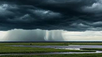
Why Is This Happening?
This intense rainfall is driven by the strengthening of the Southwest Monsoon, particularly the Bay of Bengal branch. Strong southwesterly winds are pulling vast amounts of moisture from the bay and dumping it onto the region. The unique geography of the Northeast, with its Himalayan foothills and steep terrain, exacerbates the situation. The mountains force the moisture-laden clouds to rise, cool, and release their water content in concentrated, high-intensity bursts. This topography makes the region inherently vulnerable to rapid runoff, flash floods in the hills, and riverine flooding in the plains below. While the monsoon is a seasonal phenomenon, climate scientists are increasingly pointing to a rise in short-duration, high-intensity rainfall events that overwhelm local drainage and amplify flood peaks, making these annual events more dangerous.
Authorities Mobilise as Risks Mount
In response to the dire forecasts, state and national disaster management agencies are on high alert. The Assam State Disaster Management Authority (ASDMA) has been actively issuing warnings based on IMD predictions, urging residents in vulnerable areas to take precautions. In Arunachal Pradesh, search and rescue operations involving the National Disaster Response Force (SDRF) and local police were launched following the landslides. The Department of Telecommunications (DoT) even activated emergency mobile roaming in affected districts to aid communication for rescue and relief. Authorities in downstream Assam districts have been instructed to maintain close vigilance and prepare for the surge of water from Arunachal Pradesh. Residents in all affected states have been advised to avoid unnecessary travel and stay away from vulnerable structures and water bodies.