




A Game-Changer Called NISAR
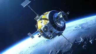
A new era in disaster management is being heralded by an advanced Earth observation satellite named NISAR, which stands for NASA-ISRO Synthetic Aperture Radar. This mission is a joint collaboration between the US and Indian space agencies and is considered
one of the most sophisticated Earth-imaging satellites ever built. Its primary goal is to provide high-resolution, all-weather data on changes to our planet's surface. For a flood-prone country like India, its potential is transformative. NISAR will systematically scan nearly the entire globe every 12 days, offering an unprecedented, consistent stream of information that will empower authorities to make faster, more informed decisions when disaster looms.
The Power to See Through Clouds
What makes NISAR so special is its core technology: Synthetic Aperture Radar (SAR). Unlike traditional optical satellites that are essentially cameras in space, SAR is an active system. It sends its own microwave signals down to Earth and reads the echoes that bounce back. This technology has a crucial advantage during the Indian monsoon: it can see right through thick clouds, heavy rain, and even the dark of night. This means that while a flood might be unfolding under a blanket of cyclonic clouds, NISAR can still map the extent of the inundation with remarkable precision. It can even detect water under forest canopies, providing a complete picture that was previously impossible to get during the critical moments of a disaster.
From Days to Hours
The true revolution lies in speed and detail. In the past, creating accurate flood maps was a slow process, often relying on patchy ground reports or optical satellite images that were only useful after the clouds cleared. By then, it was too late for proactive measures. NISAR is designed to make its data available within hours for disaster response scenarios. This allows disaster management agencies, like the NDMA, to see not just where the water is, but how it's moving. By comparing images taken just days apart, it can measure changes in water levels down to the centimetre, effectively acting as a 'virtual stream gauge' across entire river basins. This near-real-time intelligence allows for more accurate evacuation warnings, better resource allocation for rescue teams, and a clearer understanding of which areas are most at risk.
A Landmark International Partnership
NISAR is a shining example of international collaboration in space. NASA has provided the L-band radar, GPS systems, and other key components, while ISRO has contributed the satellite itself, the S-band radar, and the GSLV rocket for its launch from Indian soil. This dual-frequency capability is a world first for a satellite mission, allowing for a wider range of applications. The L-band is excellent for measuring biomass and seeing through vegetation, while the S-band is ideal for monitoring agriculture and soil moisture. This partnership ensures that the vast amounts of data—expected to be around 80 terabytes daily—are freely and openly available, benefiting scientists, disaster managers, and policymakers worldwide.
Beyond Floods: A Tool for a Changing Planet
While its impact on flood management will be immediate and profound, NISAR's mission extends far beyond that. The same technology will be used to monitor the health of Himalayan glaciers, track land subsidence from groundwater extraction, assess earthquake and landslide damage, and improve agricultural yield predictions. By providing a consistent and detailed record of changes across India's diverse landscapes, NISAR will supply crucial data for tackling the broader challenges of climate change and sustainable development. It will help us understand our dynamic planet better than ever before, providing the insights needed to protect lives and secure our future.