






The Promise of a Constant Watcher
Imagine a dedicated camera, perched 36,000 kilometres in space, with its lens focused permanently on the Indian subcontinent. That was the game-changing promise of the Geo-Imaging Satellite, or GISAT program. Most Earth observation satellites circle the globe
in low-Earth orbit, meaning they pass over a specific area for only a few minutes every few days. But a satellite in geostationary orbit moves in sync with the Earth's rotation, allowing it to 'hover' over one region. The first satellite in this series, designated EOS-03 (also called GISAT-1), was designed to be this constant watcher. It was intended to provide near real-time imagery of the country, a capability with immense value for quickly tracking natural disasters like cyclones and forest fires, monitoring agricultural land, and providing data for strategic purposes. This ability to observe fast-developing events as they unfold would have been a significant leap for India's monitoring capabilities.
What Went Wrong in 2021?
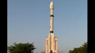
On August 12, 2021, the GSLV-F10 rocket carrying the EOS-03 satellite lifted off from Sriharikota. While the initial stages of the launch were flawless, the mission failed when the crucial third stage—the cryogenic upper stage—did not ignite. An investigation later revealed that the failure was due to a technical anomaly. A leak in a valve caused a pressure drop in the liquid hydrogen fuel tank just moments before the engine was scheduled to fire. Without the proper pressure, the engine's fuel pump malfunctioned, and the satellite could not be placed into its intended orbit, resulting in its loss. It was a significant disappointment for ISRO, delaying a much-anticipated national capability.
Why Earth Observation is Critical for India
Despite that setback, the Earth Observation (EO) program remains a cornerstone of India's space efforts, with a direct impact on national development and the lives of its citizens. Since the launch of the first Indian Remote Sensing (IRS) satellite in 1988, the program has grown into one of the world's largest civilian constellations. These satellites provide crucial data for a wide range of applications. They help in estimating crop yields, managing water resources, and finding potential groundwater sources. They are indispensable for disaster management, used for mapping flood-affected areas, assessing cyclone damage, and monitoring droughts. Furthermore, the data supports urban planning, infrastructure development, forest surveys, and coastal studies. This comprehensive monitoring, provided through platforms like ISRO's Bhuvan geoportal, aids governance, supports environmental protection, and enhances national security.
Redemption and the Road Ahead
After the 2021 failure, ISRO returned with a successor mission. On September 4, 2026, the GSLV-F17 rocket successfully launched EOS-05, the replacement for the lost satellite, placing it into the intended orbit. This successful launch marked a significant milestone, restoring confidence and finally delivering India's first imaging satellite to geostationary orbit. Looking forward, India’s EO program continues to be ambitious. A key upcoming mission is NISAR (NASA-ISRO Synthetic Aperture Radar), a powerful satellite jointly developed with NASA. Launched in July 2025, NISAR uses advanced dual-frequency radar to monitor subtle changes in the Earth's surface, like ground deformation from earthquakes, ice sheet melt, and changes in vegetation. It can see through clouds and darkness, providing highly detailed, all-weather data every few days. Another planned mission is TRISHNA, a collaboration with the French space agency CNES, which will monitor land and sea surface temperatures.