







The 'Unblinking Eye' in the Sky
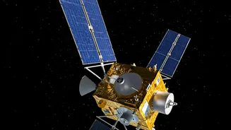
Imagine a satellite that doesn't just pass over a location once or twice a day, but stays permanently parked over the same spot on Earth. This is the core advantage of a geostationary orbit. Positioned at an altitude of approximately 36,000 kilometres,
a satellite in this orbit matches the Earth's rotation, allowing it to maintain a fixed gaze over a specific region. Unlike Low Earth Orbit (LEO) satellites, which circle the planet rapidly and can only provide snapshots of an area, a geostationary satellite offers a persistent, 24/7 watch. This ability to continuously monitor the Indian subcontinent transforms the approach to national security and strategic observation.
From Glimpses to a Constant Gaze
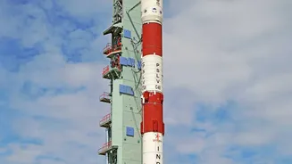
The breakthrough lies in the shift from periodic glimpses to a constant, near-real-time video feed of areas of interest. ISRO's latest geo-imaging satellite, known as GISAT or EOS-05, is designed to achieve exactly this. Previous Earth observation satellites provided valuable data but had inherent revisit gaps, meaning hours or even days could pass before they flew over the same location again. This new mission is equipped with advanced imaging instruments, including multispectral and hyperspectral sensors, capable of capturing high-resolution images. According to its mission profile, it can image the entire Indian landmass at regular intervals of around 30 minutes, and for high-priority targets, this can be accelerated to as little as five minutes. This rapid revisit capability is a game-changer for monitoring fast-developing situations.
A Force Multiplier on the Ground
For India's security forces guarding the borders, this technology acts as a powerful force multiplier. Continuous surveillance means the ability to detect and track adversary movements, identify the construction of new infrastructure near the border, and spot infiltration attempts in remote terrain with far greater accuracy. The satellite's data can provide real-time intelligence to ground patrols, helping them coordinate more effectively and respond to threats faster. By setting up virtual perimeters and receiving immediate alerts, security agencies can allocate resources more efficiently, focusing on confirmed hotspots of activity. Furthermore, the capability extends beyond simple visual tracking; advanced sensors can help in various weather conditions and contribute to a more comprehensive intelligence picture.
More Than Just a Watchman
While the strategic and military applications are profound, the benefits of this geostationary mission extend to numerous civilian sectors. The same continuous monitoring that watches over borders can also track the development of cyclones, floods, and forest fires, providing crucial data for disaster management and early warning systems. This high-frequency imaging supports a wide range of applications, including assessing agricultural health, monitoring changes in land and water resources, and tracking environmental shifts like glacier melt. The satellite essentially provides a dynamic, constantly updated map of the country, benefiting everything from urban planning to environmental conservation.
A Milestone for India's Strategic Autonomy
Developing and deploying such a sophisticated satellite indigenously is a major milestone for India's 'Atmanirbhar Bharat' (self-reliant India) initiative. Possessing a sovereign, state-of-the-art geo-imaging capability reduces the nation's reliance on foreign satellite data or intelligence for critical security and environmental monitoring. This technological achievement places India in an elite group of nations with the ability to operate geostationary imaging satellites. It not only enhances national security but also strengthens India's strategic autonomy on the global stage, showcasing the advanced capabilities of its space program in serving both civilian and defence needs.