


Start with Your Navigation App
Your first line of defence is likely already on your phone. Apps like Google Maps and Waze are indispensable tools for navigating monsoon traffic. Google Maps provides real-time traffic data, colour-coding roads to show congestion levels from green (clear)
to dark red (gridlocked). It also features crisis alerts for events like floods, often incorporating user-submitted reports of waterlogged streets. Waze thrives on its community-driven model, where users actively report accidents, road closures, and other hazards in real time, giving you a ground-level view of the chaos ahead. While these apps are excellent for identifying traffic jams that often result from flooding, they also allow you to see and report flooded roads directly, helping fellow commuters.
Lean on Localised Technology
For an experience tailored to Indian roads, consider Mappls by MapmyIndia. This homegrown navigation app offers several features that are particularly useful during the monsoon. It provides specific safety alerts for potholes, speed breakers, and accident-prone zones, which can be hidden under murky floodwaters. Mappls also includes unique features like 3D junction views to help navigate complex flyovers and intersections, which can become confusing in heavy rain. In some cities, such as Bengaluru, it has even integrated live traffic signal timers, helping you manage your journey more efficiently. Its detailed, door-level navigation and offline maps can be a lifesaver when connectivity is poor.
Check Official Government and City Channels
For authoritative information, turn to official sources. At the national level, the India Meteorological Department's (IMD) 'MAUSAM' app provides reliable weather forecasts and warnings. The Central Water Commission's 'FloodWatch' app offers real-time river flow data and flood forecasts for up to seven days. Most major cities have their own dedicated resources. For example, Mumbai has the MyBMC app, which sends push notifications about traffic diversions and flooding. Delhi Traffic Police has the 'Traffic Prahari' app for updates and reporting violations. Before heading out, make it a habit to check the official website and social media handles of your local traffic police and municipal corporation. They provide the most credible updates on road closures and diversions.
Harness the Power of Crowdsourcing
Sometimes the fastest updates come from people already stuck in the mess. Social media, particularly X (formerly Twitter), is an incredibly powerful tool for real-time information. Create a list of essential accounts to follow, including your city’s traffic police handle, local news channels, and citizen-run traffic update groups. Searching for hashtags related to your city and traffic (e.g., #MumbaiRains, #DelhiTraffic) can reveal photos, videos, and firsthand accounts of waterlogged areas that have not yet appeared on official channels. Past flood events in Chennai and Kerala have shown how volunteer-driven social media efforts can provide critical, life-saving information when official systems are overwhelmed.
Prioritise Safety Above All Else
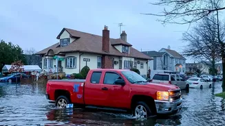
While these tools are excellent for planning your route, they are not foolproof. Conditions can change in minutes. A road that was clear moments ago can become impassable with a fresh downpour. Always exercise caution when driving through waterlogged streets. It's often impossible to gauge the depth of the water or see hidden dangers like open manholes and potholes. If the forecast is severe or you see widespread reports of heavy flooding along your route, the smartest and safest decision is often to delay your travel or stay home altogether. No meeting or errand is worth risking your safety or your vehicle. Remember that even a few inches of water can be enough to stall a car and leave you stranded.