









The Monsoon's Two Powerful Arms
The Indian monsoon isn't a single, uniform weather event. It's best understood as having two main branches, or arms, that work in tandem to water the subcontinent. The Arabian Sea branch is the first to arrive, typically making landfall on the Kerala
coast around the start of June. The second, the Bay of Bengal branch, moves up from the southeast, bringing rain to the eastern and northeastern states before moving inland towards the Gangetic plains. The behaviour and interaction of these two systems determine who gets rain, how much, and when.
A View From Space: What ISRO's Satellites See
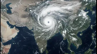
Advanced meteorological satellites like ISRO's INSAT-3DR continuously monitor India's atmosphere, providing a crucial eye in the sky. These satellites capture high-resolution images using various channels, including thermal infrared. In recent images from early July 2026, these views show vast, sprawling cloud masses over both the Arabian Sea and the Bay of Bengal. The infrared imagery highlights cloud top temperatures; extremely cold and bright white clouds indicate deep, towering systems full of moisture, signalling intense rainfall and vigorous thunderstorm activity.
The Arabian Sea's Intense Push Westward
The recent satellite data reveals a powerful system in the Arabian Sea intensifying along the Maharashtra coast. This system is fuelled by warm sea surface temperatures and strong southwesterly monsoon winds, which create an 'offshore trough' that acts like a pipeline, pumping enormous amounts of moisture onto the west coast. This has resulted in the heavy, persistent downpours experienced in Mumbai and the Konkan region. The Western Ghats play a key role here, forcing this moisture-laden air to rise, cool, and release its rain, leading to extremely heavy rainfall events in coastal Karnataka, Goa, and Maharashtra.
The Bay of Bengal's Widespread Reach
Simultaneously, an equally potent system has been brewing over the Bay of Bengal. Satellite images show an expansive shield of dense clouds blanketing coastal Odisha, Gangetic West Bengal, and extending into Bangladesh. Unlike the Arabian Sea's coastal focus, the Bay of Bengal branch is known for creating low-pressure areas and depressions that travel deep inland. These systems are crucial for bringing rainfall to central and northern India. The recent activity has fuelled widespread rain across West Bengal, Jharkhand, Bihar, and the northeastern states, with the system expected to move further west-northwestward.
A Dynamic and Volatile Partnership
The most fascinating aspect revealed by the recent ISRO imagery is the simultaneous and powerful activation of both these systems. When both the Arabian Sea and Bay of Bengal 'fire up' together, the core monsoon zone across central India receives heavy, sustained rainfall. This dual-system event highlights the increasing volatility of the monsoon, potentially influenced by broader climate patterns like record warming of the seas. This dynamic interplay—sometimes a tug-of-war, other times a coordinated push—is what dictates the nationwide distribution of rain, leading to floods in one region while another waits for relief. The ability to monitor this complex dance in real-time is vital for more accurate forecasting.