





Your First Check: Google Maps and Apple Maps
The most common navigation tools on your phone are often the best place to start. Both Google Maps and Apple Maps provide real-time traffic data, which is invaluable during a downpour. The colour-coding system—green for clear, orange for some congestion,
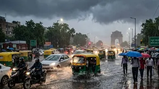
and red or dark red for heavy traffic—is your first clue. Critically, these apps often display road closure alerts. During heavy rains, check for 'closed road' icons or notifications along your intended path. These are generated from official sources and user reports, giving you a dynamic view of routes that have become impassable due to waterlogging or diversions. For example, severe waterlogging was recently reported at key areas like the Zakhira underpass, ITO, and stretches of NH-24, all of which would be flagged on these apps.
The Crowd's Wisdom: Waze
While Google Maps owns Waze, the latter operates with a greater emphasis on community-driven, real-time alerts. Waze users are highly active in reporting everything from traffic jams and accidents to specific hazards like potholes and, most importantly, waterlogged streets. During a monsoon event, Waze can be faster than other services at identifying a newly flooded underpass or a fallen tree because the alerts come directly from drivers who are on that route at that moment. If you see multiple alerts for “Flood” or “Hazard on road” on your proposed route, it is a strong signal to find an alternative.
The Official Word: Delhi Traffic Police Channels
For the most authoritative information, turn to the official channels. The Delhi Traffic Police is highly active on social media, particularly on X (formerly Twitter), during weather emergencies. They provide real-time updates on specific diversions, road closures, and traffic movement. These advisories are crucial as they detail official detours, such as recent ones suggesting commuters from Ghaziabad use the Sector 62-Vasundhara route to enter Delhi to avoid a waterlogged NH-24. Following their official handle and checking their feed before you leave can provide clarity that even navigation apps might miss. The police also use a WhatsApp chatbot and a helpline number (1800110093) to register waterlogging complaints, indicating their focus on monitoring the situation.
Hyperlocal Intel: Social Media and Community Groups
Sometimes the most relevant information is the most local. Searching for hashtags like #DelhiRains, #GurgaonTraffic, or #NoidaWaterlogging on platforms like X and Instagram can reveal real-time photos and videos from fellow commuters. This can give you a visual confirmation of the situation on the ground. Beyond public social media, many Resident Welfare Associations (RWAs) and neighbourhood groups operate WhatsApp or Telegram groups. These are invaluable for hyperlocal updates, warning you about a flooded street right in your sector or a blocked internal road that major apps might not have registered yet. This is especially useful in areas like Sangam Vihar, CR Park, or various sectors in Noida and Gurugram known for quick inundation.
Made for India: Mappls App
For a more India-centric option, the Mappls app (formerly MapmyIndia) is a powerful tool. It offers detailed maps and real-time traffic updates specifically tailored for Indian road conditions. Mappls prides itself on its house-level address search and often has robust data on road classifications, service lanes, and other features unique to Indian cities. During monsoons, its ability for users to report issues like waterlogging, potholes, and faulty street lights can provide an extra layer of granular information to help you plan your journey more safely. The app also integrates with Android Auto and Apple CarPlay for easier in-car use.
Know Before You Go: Understanding Waterlogging Hotspots
Beyond checking apps, having local knowledge of perennial waterlogging hotspots is critical. Delhi's outdated drainage system, designed in 1976, is often overwhelmed by intense rainfall. Areas like the Minto Bridge underpass, ITO, Ashram Chowk, Ring Road near Andrews Ganj, and stretches of the Mehrauli-Gurgaon road are notorious for flooding. In Gurugram, NH-48 near Narsinghpur, Sohna Road, and Rajiv Chowk are frequently affected. Recent advisories have often prompted corporate offices in Gurugram to issue work-from-home directives to avoid traffic chaos. If your route includes any of these known trouble spots, it’s wise to either delay your travel or plan a significantly different route from the outset.