









A View From Geostationary Orbit
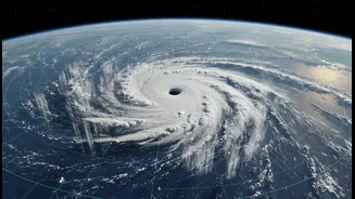
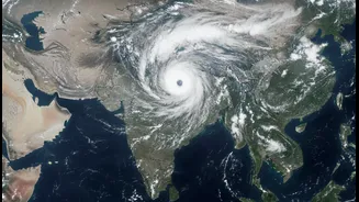
Recent images released by the Indian Space Research Organisation (ISRO) showcase the sheer magnitude of the southwest monsoon. The pictures, captured by the INSAT-3DR satellite, display vast, swirling cloud masses stretching over the Arabian Sea and the Bay
of Bengal. These are not just any clouds; their bright white appearance in infrared imagery indicates deep, moisture-laden convective systems, the engines of the monsoon's heavy rainfall. One powerful system can be seen moving from the Arabian Sea onto the Konkan coast, while another dominates the Bay of Bengal, affecting West Bengal and northeastern states. This twin-system activity signifies a vigorous and active phase of the monsoon, with both major branches firing simultaneously to drench large parts of the country.
The Eye in the Sky: What is INSAT-3DR?
Launched in 2016, INSAT-3DR is one of India’s most sophisticated meteorological satellites, orbiting in sync with the Earth to provide constant coverage of the Indian subcontinent. It serves as a crucial eye in the sky, working alongside its predecessor, INSAT-3D, to monitor weather patterns around the clock. The satellite is equipped with a multi-spectral imager that can see in six different wavelength bands, allowing it to generate detailed images day and night. It also carries an atmospheric 'sounder', a remarkable instrument that provides vertical profiles of temperature and humidity through the atmosphere. This technology allows meteorologists to not just see the clouds, but to understand the conditions within and around them, dramatically improving forecasting accuracy.
Understanding the 'Active Monsoon Phase'
The term 'active monsoon phase' describes a period of intense and widespread rainfall, and the latest satellite images show exactly that. The India Meteorological Department (IMD) has forecast heavy to very heavy rainfall across several regions, including the west coast, central India, and eastern states. Recent activity has been particularly strong over Maharashtra and West Bengal. This phase is crucial for a country that receives about 70% of its annual rainfall during the monsoon months. While these rains are vital for agriculture and replenishing water reservoirs, an active phase also brings the risk of flooding, landslides, and disruption to daily life, especially in vulnerable low-lying areas and crowded cities. The IMD has issued alerts for regions like Konkan, Goa, and parts of Gujarat to remain vigilant.
More Than Just a Pretty Picture
The data from INSAT-3DR is far more than just visually impressive; it is a lifeline for millions. ISRO provides this critical data to the IMD, which uses it for everything from daily weather bulletins to early warnings for cyclones and severe storms. The satellite's ability to monitor cloud formation, track storm systems, and even estimate rainfall helps disaster management agencies prepare and respond effectively. Furthermore, its Data Relay Transponder collects information from over a thousand automatic weather and rain gauge stations across the country, creating a comprehensive, real-time picture of the national weather situation. This integration of space technology into governance strengthens India's resilience against the often-unpredictable nature of the monsoon, helping to safeguard lives and infrastructure.
The 2026 Monsoon: A Season of Contrasts
This year's active phase comes after a complex start to the season. While recent weeks have brought intense downpours, the overall forecast for the 2026 monsoon has been cautious. Meteorologists had initially noted a weaker start, with some predictions pointing towards below-normal rainfall for the season as a whole, partly due to emerging El Niño conditions. June was particularly dry, delaying crop sowing in many agricultural belts. However, the current active phase, with the monsoon expected to cover the entire country in the coming days, has brought much-needed relief and is vital for making up the deficit. This highlights the monsoon's inherent variability and the critical importance of continuous, high-quality satellite monitoring to track its progress day by day.