


Seeing with Sound
At its core, sonar—short for Sound Navigation and Ranging—is a technology that uses sound waves to ‘see’ in the water. A transmitter sends out a pulse of sound, which travels through the water and bounces off objects like the seabed or, in this case,
potential man-made structures. A receiver then picks up the returning echo. The time it takes for the echo to return reveals the distance to the object, and the strength of the echo provides clues about its size and material. It's the same principle bats use for navigation, but applied to the vast, murky world of underwater archaeology.
The Tools for the Hunt
Scientists from institutions like India's National Institute of Oceanography (NIO) and the Archaeological Survey of India (ASI) don't use just any sonar. They employ sophisticated systems like side-scan sonar and multibeam echosounders. Side-scan sonar is towed from a vessel and sends out wide, fan-shaped beams of sound to either side, creating detailed, almost photographic images of the seabed's texture. Strong reflections can indicate hard objects like stone blocks, distinguishing them from the softer surrounding sand. Multibeam echosounders, on the other hand, map the depth and topography of the seabed with incredible precision, creating 3D models that can reveal the tell-tale geometric shapes of walls and buildings. Together, these tools paint a comprehensive picture of what lies hidden.
The Search in Action
The process begins with a survey vessel methodically crisscrossing the target area, typically a few hundred metres to a kilometre off the coast, in water depths of 5 to 15 metres. As the boat moves, the sonar equipment constantly pings the seabed, gathering millions of data points. This raw data is then fed into powerful computers that process the soundings and stitch them together into a coherent map. Analysts look for anomalies—patterns that don't look natural. These might include long, linear features suggesting walls, clusters of rectangular blocks, or raised platforms. These are the digital breadcrumbs that lead archaeologists to promising locations for further investigation.
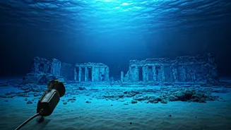
From Digital Signal to Ancient Wall
Once a promising target is identified on the sonar scan, the next step is physical verification. This is where underwater archaeology takes over. In the past, this meant teams of divers physically exploring the locations pinpointed by the sonar. They would descend to the seabed to see the structures firsthand, take measurements, and document their findings. More recently, teams have begun using Remotely Operated Vehicles (ROVs). These unmanned submersibles are equipped with high-resolution cameras, allowing researchers to explore deeper and in more challenging conditions, capturing clear video of the submerged remains without disturbing the site. This crucial step confirms whether a sonar anomaly is just an interesting rock formation or the remnant of a Pallava-era wall.
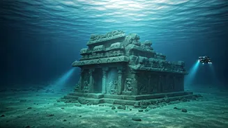
What Has Sonar Revealed?
Thanks to these sonar-led explorations, the legend of Mahabalipuram's lost city is moving closer to fact. Joint projects between the NIO and ASI have successfully used sonar to identify and then visually confirm numerous man-made structures. Discoveries have included submerged walls, scattered dressed stone blocks, and what appear to be steps leading to a platform. In some cases, structures found were as much as 800 metres from the current shoreline. While a full temple complex matching the legend of seven pagodas remains elusive, the sonar data has confirmed the presence of a significant submerged settlement. These findings suggest that the city of Mahabalipuram was once much larger, with parts of it lost to the sea over centuries due to coastal erosion or tsunami events.