





Beyond Just Seeing the Clouds
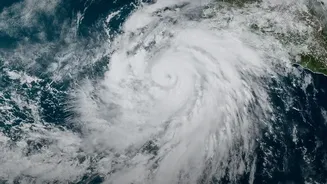
For decades, weather forecasting relied heavily on two main tools: ground-based radar and early-generation satellites. Ground radar is excellent but has its limits; its signals can be blocked by mountains, and its range is finite. Early satellites could
see the tops of clouds, giving a good overview of weather systems but telling us little about what was happening inside them. They could show a large, menacing cloud mass but couldn't accurately differentiate between one that would produce light drizzle versus one that was about to unleash a torrential downpour. This is a critical distinction, as storm intensity—the rate at which rain falls—is what determines whether a city's drainage system holds or is overwhelmed, leading to flash floods. Forecasters needed a way to peer inside the storm itself.
A New Generation of Eyes in the Sky
Enter the era of advanced satellite sensors. Today’s weather satellites, including India's own INSAT series like INSAT-3D and the recently launched INSAT-3DS, are equipped with sophisticated instruments that go far beyond simple visual imaging. Two key technologies are passive microwave radiometers and active precipitation radar. Think of passive microwave sensors as being able to 'listen' to the faint energy signatures emitted by water vapour and raindrops within a cloud. Active radar, on the other hand, sends out a pulse of energy and measures what bounces back, creating a detailed, three-dimensional map of the precipitation inside the storm. This is like having an X-ray for a storm cloud, revealing its internal structure and intensity.
From Pixels to Precise Predictions
These advanced sensors provide a flood of data that helps forecasters model a storm's behaviour with much greater accuracy. Microwave radiometers can distinguish between the 'cold' signature of an ocean surface and the 'warm' signature of raindrops, allowing them to estimate rainfall rates over vast stretches of water where ground gauges don't exist. They can also detect the presence of ice particles high in a storm, which is often a clue that strong updrafts are present, signalling a more severe and intense weather event. The data from these sensors, particularly those on missions like the Global Precipitation Measurement (GPM) satellite, feeds directly into the complex numerical weather prediction models used by agencies like the India Meteorological Department (IMD). This allows them to create more accurate forecasts, updating them as frequently as every 15 to 30 minutes, which is vital for issuing timely warnings.
Building a More Resilient India
This technological leap is central to the concept of climate resilience, which is the ability to anticipate, prepare for, and respond to climate-related hazards. For India, a nation heavily reliant on the monsoon and increasingly vulnerable to extreme weather, this is not an abstract idea. More accurate forecasts of rain intensity directly translate into life-saving benefits. They enable the IMD to issue specific, actionable warnings for flash floods and cyclones, giving disaster management authorities crucial lead time for evacuations. For farmers, these precise predictions help in planning irrigation and harvesting, protecting livelihoods. For urban planners, understanding the intensity of expected rainfall helps in designing better drainage infrastructure to cope with the 'new normal' of more frequent, intense downpours. By improving our ability to see what's coming, these satellites help us move from a reactive to a proactive stance against climate change's impacts.