



Understanding Official Weather Warnings
Your first step in safe monsoon travel is understanding the alerts issued by the India Meteorological Department (IMD). The IMD is the primary government agency for weather forecasting and uses a colour-coded system to communicate the severity of expected
weather. A Green alert means 'No Warning,' while a Yellow alert advises you to 'Be Updated.' An Orange alert means 'Be Prepared' for potentially disruptive weather. A Red alert, the most serious, signals a need to 'Take Action,' as severe weather could pose a significant risk to life and property. Before and during your trip, paying attention to these codes for your destination district is a non-negotiable part of your travel plan. These alerts are crucial for deciding whether to proceed with, delay, or cancel your travel plans, especially if heading to hilly or coastal regions.
Essential Government Websites to Bookmark
For comprehensive and reliable information, official government websites are your best resource. The IMD's main portal, mausam.imd.gov.in, provides detailed district-level forecasts, rainfall information, and active warnings for the entire country. Another critical resource is the National Disaster Management Authority (NDMA) and its state-level counterparts (SDMAs). These sites issue specific advisories on hazards like landslides and flash floods, identify vulnerable areas, and provide safety protocols. For landslide-specific information, the Geological Survey of India (GSI) has recently launched a portal called 'Bhusanket' and the National Remote Sensing Centre (NRSC) maintains a 'Landslide Atlas of India' which details vulnerable zones. Checking the SDMA website for your specific destination state, such as those for Uttarakhand, Kerala, or Maharashtra, can provide hyper-local and critical updates that national portals might not detail.
Your Digital Toolkit: Must-Have Mobile Apps
For real-time updates on the go, several government-backed mobile applications are indispensable. The 'Mausam' app is the IMD's official, all-in-one tool for the public, providing current weather, forecasts, radar images, and colour-coded alerts. For a more specific hazard, the 'Damini' app provides early warnings for lightning strikes, alerting users 30-40 minutes in advance for an area within a 40 km radius. Another useful tool is 'Meghdoot', which, while designed for farmers, offers valuable localised weather and crop advisories that can be useful for any traveller. The NDMA's 'Sachet' app consolidates disaster-related alerts, including those for floods and storms, from various agencies onto one platform. Recently, the GSI also launched an app called 'Bhooskhalan' to provide early warnings for rainfall-induced landslides in vulnerable districts.
Checking for Landslide Specific Alerts
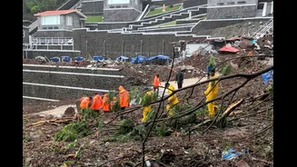
Landslides are one of the most significant dangers of monsoon travel in hilly regions. While general weather apps provide rainfall data, specific landslide warnings require dedicated sources. The newly launched 'Bhooskhalan' app and 'Bhusanket' portal from the Geological Survey of India (GSI) are designed to provide forecasts for rainfall-induced landslides, initially covering several vulnerable districts in states like West Bengal, Uttarakhand, and Kerala. The National Remote Sensing Centre's Landslide Atlas provides a macro view of landslide-prone zones across the country, which is useful for initial planning. Additionally, many SDMA websites, like those for Uttarakhand and Jammu & Kashmir, often have sections dedicated to landslide vulnerability and real-time road status updates. It's crucial to check these resources, as heavy rainfall is a primary trigger, and an IMD red or orange alert for rain in a hilly area should automatically be treated as a high-risk situation for landslides.
Beyond Tech: On-the-Ground Intelligence
Technology is a powerful tool, but it should be supplemented with on-the-ground intelligence. Before and during your trip, speak with locals, your hotel staff, and local drivers. They often have the most current information about road conditions, potential blockages, and unsafe areas that may not have reached an official portal yet. Avoid driving in hilly areas at night during heavy rain, as visibility is low and the risk of falling debris is high. Always maintain a safe distance from overflowing rivers and streams, as water levels can rise with alarming speed. Have a flexible itinerary with buffer days built in to account for potential delays from road closures or cancelled transport. A well-charged power bank, extra food and water, and a first-aid kit are essential components of any monsoon travel pack. Being prepared for the unexpected is just as important as checking the forecast.