


The Challenge of Seeing in a Storm
Traditionally, monitoring floods from space relied on optical satellites, which are essentially powerful cameras orbiting Earth. They capture high-resolution images that are invaluable for assessing damage, but they have a fundamental weakness: they cannot
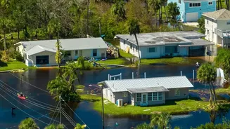
see through clouds. During a major flood event, like those common in India’s monsoon season, persistent cloud cover can render these satellites useless for days. This means that at the precise moment when emergency teams need to know the extent of the flooding to rescue people and deliver aid, their view is completely blocked. Ground-based sensors can also be costly, time-consuming to deploy, and are often washed away or inaccessible in remote areas, creating a dangerous information gap.
An Eye That Pierces Through Clouds
This is where Synthetic Aperture Radar, or SAR, changes the game. Unlike optical satellites that passively capture reflected sunlight, SAR is an active system. It works by sending its own microwave signals down to Earth and then measuring the 'backscatter' that bounces back. Because these radar waves have a much longer wavelength than visible light, they can effortlessly penetrate clouds, rain, smoke, and even darkness. This gives SAR satellites the remarkable ability to provide clear, detailed images of the ground day or night, regardless of the weather conditions—a capability crucial for effective disaster response.
Turning Radar Signals into Flood Maps
So how does a radar signal translate into a map of a flooded village? The process is elegantly simple. The key lies in how different surfaces reflect the radar signal. Rough surfaces, like land, forests, and buildings, scatter the signal in many directions, causing a significant portion of it to bounce back to the satellite sensor. These areas appear bright in a SAR image. In contrast, a calm, smooth surface like standing floodwater acts like a mirror. It reflects the radar signal away from the satellite, resulting in very little backscatter. Consequently, flooded areas appear as dark patches on the image. By comparing a pre-flood 'baseline' image with one taken during the flood, scientists can instantly see these new dark areas and precisely map the water's extent.
From Data to Life-Saving Action
This near real-time mapping capability is a lifeline for disaster management agencies. In India, organisations like the Indian Space Research Organisation (ISRO) and the National Disaster Management Authority use data from satellites, including SAR missions, to monitor floods across the country. During major events, ISRO generates and disseminates dozens of flood inundation maps to state and central authorities. These maps show which villages are submerged, which roads are cut off, and where elevated dry ground might still exist. This allows response teams to prioritise rescue operations, plan safer evacuation routes, and deliver supplies to the most critically affected populations with unprecedented speed and accuracy.
The Future: A Sharper, More Frequent View
The technology is only getting better. The upcoming NASA-ISRO Synthetic Aperture Radar (NISAR) mission is set to revolutionize flood monitoring. A joint project between the two space agencies, NISAR will be one of the most advanced radar imaging satellites ever built. It will scan nearly the entire globe every 12 days, providing consistent and reliable data at a high resolution. Its advanced radar will even be able to detect water hidden beneath forest canopies, a feat difficult for many current systems. For a flood-prone nation like India, NISAR will provide a powerful stream of data to improve early warning systems, refine flood models, and build greater resilience against the growing threat of extreme weather events.