






The Dream of a Constant Watch
Most Earth-observation satellites circle the globe in Low Earth Orbit (LEO), getting only fleeting glimpses of any single location. While incredibly useful, they can't provide the continuous monitoring needed to track rapidly developing events like a cyclone
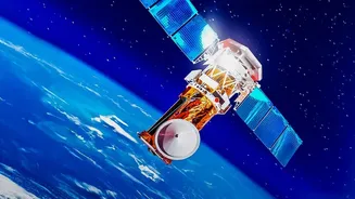
making landfall or a forest fire spreading. A Geostationary Imaging Satellite (GISAT) is different. It is placed in a high orbit about 36,000 kilometres above the Earth, where its speed perfectly matches the planet's rotation. To an observer on the ground, it appears to hang motionless in the sky, allowing it to stare at the Indian subcontinent constantly. This capability is a game-changer, enabling near real-time updates that could transform disaster management and national security.
A Tale of Two Missions: The GISAT Saga
The path to this capability has been challenging. The headline mission, GISAT-1A, is actually a story of redemption. Its predecessor, GISAT-1 (also known as EOS-03), was lost during a launch in August 2021. The mission failed because the GSLV rocket's cryogenic upper stage did not ignite, preventing the satellite from reaching its intended orbit. This was a significant setback. Now, nearly five years later, ISRO is ready for a second attempt with GISAT-1A (also designated EOS-05), which is scheduled for launch on September 4, 2026. This mission carries not just a satellite, but the weight of ISRO's ambition to secure a permanent perch in the geostationary orbit.
Why This 'Sky Eye' Is Crucial for India
The strategic importance of a satellite like GISAT-1A cannot be overstated. For disaster management, it means the ability to track cyclones and floods with an unprecedented frequency, imaging a specific area as often as every five minutes. This allows for more accurate predictions and timely evacuations. For agriculture, it can monitor crop health, soil moisture, and the impact of drought over large areas. And for national security, the ability to maintain a constant watch over borders and maritime areas provides a significant intelligence advantage, offering a persistent surveillance capability that other nations like China have also been developing. It is a tool for civilian protection and strategic advantage rolled into one.
More Than a Single Satellite
While GISAT-1A is a crucial mission, it's important to see it as one part of a larger network. India, through ISRO, operates one of the world's largest constellations of remote sensing satellites. Missions like the Cartosat series provide high-resolution mapping, while the RISAT series offers all-weather observation using radar. These satellites operate in different orbits and provide different types of data, creating a multi-layered observation system. The failure of the original GISAT-1 was a hurdle, but it did not cripple India's overall Earth-observation capabilities, which remain robust and diverse. GISAT-1A is designed to add a unique and powerful new dimension to this existing network.
The Road Ahead: Resilience and Ambition
The upcoming launch of GISAT-1A on September 4 is a critical test for ISRO. It is an opportunity to overcome the 2021 failure and finally place a powerful imaging satellite into the coveted geostationary slot. A successful mission would not only deliver on a long-held technological promise but also reinforce the resilience of India's space program. It demonstrates that space exploration is a journey of perseverance, where setbacks are analyzed, lessons are learned, and ambitions are pursued with renewed determination. The successful operation of GISAT-1A would significantly enhance India's ability to safeguard its people, manage its resources, and monitor its strategic interests from a unique vantage point high above the Earth.