






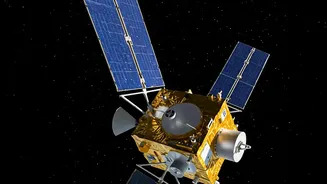

A New Sentinel in the Sky
In the early hours of September 4, 2026, the Indian Space Research Organisation (ISRO) successfully launched its advanced Earth Observation Satellite, EOS-05, into orbit. Dubbed an 'eye in the sky', this satellite is not just another addition to India's
impressive space fleet; it represents a strategic leap forward. Placed in a geosynchronous orbit approximately 36,000 km above the Earth, EOS-05 will hover over the Indian subcontinent, maintaining a constant watch. Unlike other observation satellites that pass over a location at intervals, EOS-05’s fixed position allows for near-continuous monitoring of the entire country, from the Himalayas to the Indian Ocean. This mission is a testament to ISRO's resilience, especially following previous launch setbacks, and it heralds a new, more dynamic phase in how India prepares for and responds to natural calamities.
The Geosynchronous Advantage
The key to EOS-05's power lies in its unique orbit. Most Earth observation satellites, like those in the RISAT or Cartosat series, are in Low Earth Orbit (LEO), circling the globe at lower altitudes. While LEO satellites provide very high-resolution images, they can only view a specific location for a short time before moving on. For rapidly developing events like cyclones or flash floods, this intermittent coverage can be a limitation. EOS-05, as India's first imaging satellite in geosynchronous orbit, overcomes this. By matching the Earth's rotation, it can provide frequent images of large areas—capturing the entire Indian landmass every 30 minutes. This 'persistent stare' capability is a game-changer for disaster management, allowing authorities to track the evolution of a threat in near real-time.
Seeing Through Nature's Fury
EOS-05 is equipped with state-of-the-art imaging instruments, including multi-spectral and hyperspectral sensors that can see across various light bands. This technology allows it to do more than just take pictures. For cyclones, it can track cloud formations, measure wind speed, and help the India Meteorological Department (IMD) predict a storm's path and intensity with greater accuracy. In the case of floods, which often occur under heavy monsoon cloud cover, the satellite's capabilities are crucial. While optical sensors are blocked by clouds, other specialised instruments can penetrate them, providing clear views of inundated areas. This enables authorities to generate precise flood maps, identifying the worst-hit villages and infrastructure, even when they are hidden from plain sight. The satellite's data feeds directly into platforms like the National Database for Emergency Management (NDEM), giving responders actionable intelligence.
Beyond Floods and Cyclones
The satellite's utility extends far beyond monitoring water-related disasters. Its imagers are designed to detect a wide range of environmental changes. For India's vast agricultural sector, it can monitor crop health, soil moisture, and assess drought conditions on a national scale. During the summer months, it will serve as a vigilant watchdog for forest fires, spotting initial outbreaks before they grow into uncontrollable infernos. Its high-resolution cameras will also be invaluable for monitoring geologically sensitive areas, like the Himalayan region, for signs of glacial lake outbursts or landslips. The data gathered will not only aid in immediate response but will also contribute to long-term risk assessment and mitigation planning, helping to build more resilient communities and infrastructure.
A Strategic National Asset
The successful deployment of EOS-05 is a landmark achievement for ISRO and a significant boost to India's national capabilities. It reduces the country's reliance on foreign satellite data and provides a sovereign tool for both civilian and strategic applications. The ability to provide near real-time, large-scale imagery has implications for everything from urban planning and water resource management to border surveillance. This mission underscores the vital role that space technology plays in national development and security. By turning raw satellite data into life-saving information, ISRO is not just conquering space, but also making life on Earth safer for over a billion people.