







What Exactly Is El Niño?
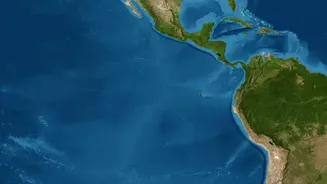
El Niño is a climate phenomenon characterized by the unusual warming of sea surface temperatures in the central and eastern equatorial Pacific Ocean. Under normal conditions, trade winds blow from east to west, pushing warm surface water towards Asia
and Australia. During an El Niño, these trade winds weaken, or even reverse, allowing the warm water to spread eastward toward the Americas. This shift in ocean heat is significant enough to alter global atmospheric circulation, disrupting weather patterns worldwide and often triggering a cascade of effects, from floods in South America to droughts in Southeast Asia and India.
The Historical Link to India's Monsoon
For India, the primary concern is El Niño's strong correlation with weaker southwest monsoon seasons. The monsoon is the lifeblood of the nation's agriculture, with nearly half of the net sown area being rain-fed. Historically, a significant number of El Niño years have coincided with below-average rainfall and even droughts in India. This happens because the atmospheric changes caused by El Niño can suppress the formation of rain-bearing clouds over the subcontinent. However, the relationship isn't a simple one-to-one equation. Not every El Niño year results in a drought; in fact, some have seen average or even above-average rainfall, like the strong El Niño year of 1997-98. This highlights that other climatic factors are always at play.
The 2026 Forecast: A Strong Event Brewing
Meteorological agencies are closely monitoring the Pacific, where a strong El Niño event is forecast to intensify through late 2026. According to the U.S. National Oceanic and Atmospheric Administration (NOAA), there is a high probability of a 'strong' El Niño developing, potentially becoming one of the most powerful events recorded since 1950. The India Meteorological Department (IMD) has also acknowledged the strengthening El Niño. In late July, the IMD forecast below-normal rainfall for August, citing the persistent El Niño conditions. However, despite these forecasts, India has also been experiencing intense rainfall in several regions in mid-August due to other active weather systems, like low-pressure areas in the Bay of Bengal.
A Potential Saviour: The Indian Ocean Dipole
While El Niño hogs the spotlight, another phenomenon in our own backyard, the Indian Ocean Dipole (IOD), plays a crucial role. The IOD refers to the temperature difference between the western and eastern parts of the Indian Ocean. A 'positive' IOD, with warmer waters in the Arabian Sea, can help boost monsoon rains over India and potentially counteract the negative effects of El Niño. Recent observations from August 2026 indicate that a positive IOD is indeed developing and expected to strengthen. This could be a saving grace for the latter half of the monsoon season, although the exact extent of its influence remains to be seen.
What's at Stake for India?
The performance of the monsoon has far-reaching consequences. A deficit in rainfall can lead to reduced crop yields, particularly for key kharif crops like rice, cotton, and soybean, potentially driving up food inflation. It also affects water levels in reservoirs, which are crucial for drinking water supply, irrigation for winter crops (rabi season), and hydroelectric power generation. The economic impact can be significant, affecting rural consumption, government finances, and overall economic growth. While the erratic nature of the 2026 monsoon has already created challenges, the combined influence of a strong El Niño and a developing positive IOD makes the final outcome highly complex to predict.