


Understanding the IMD's Warning
The IMD has issued 'orange' and 'yellow' alerts across different parts of the region, signaling the imminent arrival of significant rainfall. An orange alert indicates a forecast of very heavy rain, typically between 115.6 mm and 204.4 mm in a 24-hour
period, and advises residents to 'be prepared' for potential disruptions like waterlogging and traffic snarls. [8, 11] A yellow alert signifies heavy rainfall, between 64.5 mm and 115.5 mm, where citizens are advised to 'be aware' of the changing weather conditions. [8, 9] These alerts are crucial for public safety, helping citizens and local administrations prepare for adverse weather and minimize risks associated with intense monsoon spells. The current alerts cover the next 48 to 72 hours, with weather conditions expected to be closely monitored.
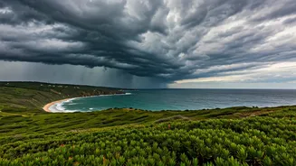
Which Areas Are Most Affected?
The alert is primarily focused on the districts falling under Central Maharashtra, also known as Madhya Maharashtra, and the adjacent Marathwada region. While the Konkan coast often receives the first and most intense monsoon showers, this particular system is strengthening over the state's interior. [28] Key districts on alert include Pune, Nashik, Satara, and Ahmednagar in Madhya Maharashtra, along with parts of Marathwada like Chhatrapati Sambhajinagar (formerly Aurangabad). [22, 23] Residents in these areas, especially those in low-lying zones or near rivers, are advised to be particularly cautious. Urban centers like Pune and Nashik may experience localized flooding and traffic disruptions due to the intense spells of rain. [23]
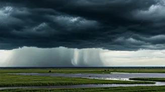
What is an Active Monsoon Trough?
The primary cause of this intensified rainfall is a weather phenomenon known as a monsoon trough. [15] In simple terms, a trough is an elongated area of low pressure that acts like a highway for monsoon winds carrying moisture from the sea. [5, 13] The normal position of the monsoon trough runs across the northern plains of India. [20] When this trough becomes 'active' and shifts its position, it can dramatically influence rainfall patterns. [5] An active trough pulls in a large amount of moisture-laden winds from the Arabian Sea, which then rise, cool, and condense into dense rain clouds, leading to sustained and heavy downpours over the region it influences. [15, 17] This system is a fundamental part of India's southwest monsoon, responsible for both widespread beneficial rains and, at times, severe flooding events.
Essential Safety Precautions for Residents
With heavy rain expected, it is vital for residents to prioritize safety. The IMD and disaster management authorities have issued several key recommendations. Firstly, avoid wading through or driving in waterlogged areas, as floodwaters can hide open manholes, debris, and downed power lines. [6, 10] It is also advisable to stay away from electric poles and unplug non-essential electrical appliances at home to prevent short circuits. [7] Before venturing out, check vehicle vitals like tyres and wipers, and if possible, avoid using two-wheelers during heavy downpours. [6, 7] For those living in vulnerable structures or areas prone to landslides, it is important to be prepared for possible evacuation and to know the location of local shelters. [18]
How to Stay Informed and Prepared
Staying updated with the latest weather information is crucial during such events. Rely on official sources like the IMD's website and its social media channels for credible forecasts and warnings. [18] It's also wise to prepare a basic emergency kit at home. [6] This should include essentials like a flashlight with spare batteries, a first-aid kit, some dry food, drinking water, and a power bank to keep your mobile phone charged. [18] Keeping important documents in a waterproof bag is another practical step. [6] Sharing information with family and neighbours ensures that the entire community remains alert and prepared for any eventuality. Following instructions from local civic and police authorities will help ensure safety and order during the wet spell.