





Our Eyes in the Sky
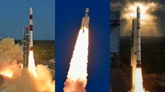
At its core, Earth Observation (EO) is exactly what it sounds like: the use of satellites to gather information about our planet. For decades, space agencies like the Indian Space Research Organisation (ISRO) have been launching satellites that do more
than just relay communications; they constantly monitor our land, oceans, and atmosphere. These satellites are equipped with powerful sensors that capture data far beyond what the human eye can see. This capability has moved from a niche scientific curiosity to the backbone of how Indian agriculture is monitored on a massive scale.
From Pixels to Plant Health
A satellite doesn’t just take a simple picture. It captures data across different parts of the light spectrum, including infrared. This allows scientists and agronomists to calculate what’s known as a Vegetation Index, such as the widely used Normalized Difference Vegetation Index (NDVI). In simple terms, NDVI is a measure of a plant's greenness, which is a direct indicator of its health and photosynthetic activity. A healthy, thriving crop reflects light differently than one that is stressed by drought, pests, or nutrient deficiency. By analysing these spectral signatures, experts can map crop health across vast regions without ever setting foot in the field, detecting stress weeks before it becomes visible on the ground.
The Power of Prediction
Collecting data is only the first step. The real magic happens when this continuous stream of information is combined with artificial intelligence (AI) and machine learning. Predictive models are fed with satellite data on crop greenness, soil moisture, and land surface temperature, along with historical weather patterns and past yield records. Over time, these algorithms learn the complex relationships between what the satellite sees during the growing season and the final harvest outcome. This allows initiatives like ISRO's FASAL (Forecasting Agricultural output using Space, Agro-meteorology and Land-based observations) program to issue in-season forecasts for major crops like rice and wheat, giving policymakers a vital head-start.
Real-World Impact for India
This technology is not just an academic exercise; it has profound implications for India. For the government, accurate yield predictions are crucial for managing national food stocks, making informed decisions on imports or exports, and deploying aid during droughts or floods. For farmers, especially smallholders, the benefits are becoming more direct. These insights can inform better resource management, such as the precise application of water and fertilisers, which reduces costs and environmental impact. Furthermore, satellite data provides objective evidence for crop damage assessments, which can streamline insurance claims under schemes like PMFBY and even support loan applications by providing verifiable proof of crop coverage and health.
Overcoming the Hurdles on the Ground
Despite its immense potential, the widespread adoption of EO technology faces challenges. A key issue during the Kharif season is cloud cover, which can block optical satellites; however, the increasing use of radar-based satellites, which can see through clouds, is helping to mitigate this. Other barriers include the high cost of specialised data, the need for technical expertise to interpret the information, and the digital divide that can prevent insights from reaching the most remote farmers. Bridging this gap requires not just better technology, but also creating accessible tools, like mobile apps and decision support systems such as Krishi-DSS, that translate complex data into actionable advice for farmers.