



Seeing the Invisible
Satellite imaging isn't just about capturing what the human eye can see. Many Earth observation satellites are equipped with advanced sensors that detect light beyond the visible spectrum, like infrared and microwave radiation. These sensors can measure
everything from the temperature of the ocean's surface and the moisture in the soil to the concentration of greenhouse gases in the atmosphere. For example, infrared imagery can reveal the health of vegetation by detecting subtle changes in plant tissue that are invisible to us. Radar satellites have the powerful ability to see through clouds and even at night, making them essential for monitoring tropical regions that are often cloudy and for tracking activities like illegal logging that might happen after dark.
A Vital Tool Against Climate Change
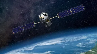
Satellites are one of our most important tools in understanding and tracking climate change. They provide a continuous and global record of key indicators. By using instruments called altimeters, which bounce radio or laser pulses off the surface, scientists can precisely measure the height of ice sheets and sea levels, tracking how quickly glaciers are melting and oceans are rising. These satellites also monitor the concentration of greenhouse gases like carbon dioxide in the atmosphere, helping to identify pollution sources. This constant stream of data from space allows researchers to build accurate models of our planet's climate system and understand the far-reaching impacts of a warming world.
Guarding Forests and Feeding the World
Monitoring our planet's vast forests and agricultural lands from the ground is a monumental task. Satellites make it possible by providing a wide-area view. Organisations and governments use this data to track deforestation and identify illegal mining or logging operations, sometimes in near real-time. The Indian Space Research Organisation (ISRO), for example, uses its constellation of Earth observation satellites for applications like forestry management, agricultural crop inventory, and monitoring land use. This data is invaluable for precision farming, allowing agronomists to identify areas within a field that might be struggling due to pests or a lack of water, thereby optimising the use of resources like fertiliser and improving crop yields.
First Responders in the Sky
When natural disasters strike, information is critical. Satellite imagery plays a crucial role in disaster management—before, during, and after an event. Before a hurricane or cyclone, weather satellites provide forecasts that help authorities issue timely warnings and prepare communities. During a flood, radar satellites can map the extent of the inundated areas, even through heavy cloud cover, guiding rescue teams to where they are needed most. After a wildfire or earthquake, high-resolution images help assess the scale of the damage to buildings and infrastructure, identify power outages, and monitor for secondary risks like landslides on burnt, unstable slopes. ISRO's recently launched EOS-05 satellite is a dedicated spacecraft designed to provide near real-time imagery specifically for disaster management and other strategic applications.
Mapping Our Changing Cities and Waterways
Beyond wild landscapes, satellites also help us manage our built environments and precious resources. They are used for urban planning, monitoring the expansion of cities and ensuring development is sustainable. This technology can also track air and water pollution, identifying hotspots and helping authorities enforce environmental regulations. For water management, satellites monitor reservoir levels, track drought conditions, and even help detect harmful algal blooms in lakes and coastal areas. In India, ISRO's Bhuvan geoportal provides data from various satellites for a wide range of governance applications, including water resource management and urban development, making this space-based technology a key asset for national progress.