


The Annual Gridlock
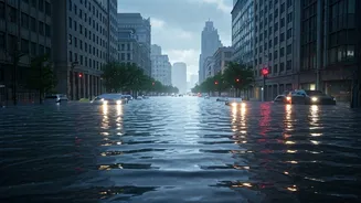
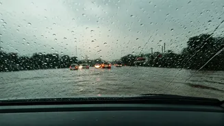
Every year, the monsoon season brings both relief from the heat and a predictable wave of disruption to urban life. Across major Indian cities like Mumbai, Delhi, and Bengaluru, heavy downpours frequently overwhelm decades-old drainage systems. This results
in severe waterlogging, turning key arterial roads and underpasses into impassable lakes. The consequence is immediate and widespread: massive traffic snarls that can trap commuters for hours, disrupting schedules and causing immense frustration. Recent reports from Mumbai highlighted how the delayed but intense arrival of monsoon rains led to significant flooding, shutting down subways and bringing traffic to a standstill, with some areas receiving over 200 mm of rain in just a few hours.
How Your Phone Knows About the Flood
The magic behind real-time traffic apps is a combination of data sources working in tandem. The primary source is you—the user. Apps like Google Maps and Waze collect anonymized location and speed data from thousands of drivers. When many phones in one area suddenly slow down or stop, the app's algorithm flags it as a traffic jam. This is enriched by crowdsourced, user-generated reports. Drivers can actively report accidents, road closures, and, crucially for monsoons, waterlogging or floods. Some advanced systems are even starting to integrate with official data sources, such as flood sensors and weather data, to create predictive models that warn drivers before they even reach a flood-prone area.
Your Best Bets for Indian Roads
While global giants are effective, it's worth knowing your options. **Google Maps:** The default for many, it provides reliable real-time traffic data, indicated by its familiar color-coded lines (green, orange, red). Its strength lies in its massive user base, which makes its traffic detection highly accurate. **Waze:** Owned by Google but community-driven, Waze excels at user-reported alerts. Drivers are very active in reporting everything from police presence to potholes and floods, providing a granular, on-the-ground view of road conditions. **Mappls (by MapmyIndia):** This homegrown app is designed specifically for Indian conditions. It offers several unique features, such as alerts for potholes, speed breakers, and sharp curves, which are invaluable on Indian roads. Mappls also boasts 3D junction views to navigate confusing flyovers and detailed house-number level navigation. Its growing popularity and deep integration with local data make it a strong contender.
Smarter Navigation Tips
Simply having the app isn't enough; using it smartly can make all the difference. **Look for Hazard Icons:** Don't just follow the blue line. Pay attention to user-reported icons for floods, accidents, or road closures that might appear along your route. These are your most immediate warnings. **Check Alternate Routes:** Apps will often suggest multiple routes. The shortest may not be the fastest, especially if it passes through low-lying, flood-prone areas. Compare the options and look for routes that stick to main, elevated roads. **Enable Voice Alerts:** During heavy rain, you need to keep your eyes on the road. Turn on voice-guided navigation and safety alerts to be notified of upcoming hazards without having to look at your phone. **Contribute Your Reports:** If you safely pass a waterlogged area, take a moment to report it. You'll be helping countless other commuters behind you. The strength of these apps lies in their community.
Beyond the App: Stay Informed
Technology is a powerful tool, but it should be part of a broader strategy. Many city traffic police departments are now highly active on social media platforms like X (formerly Twitter) and Facebook. They provide real-time updates on major waterlogging, traffic diversions, and road closures. Following your local traffic police's official handle can provide crucial information that might not yet be reflected in-app. Additionally, apps like 'Mausam', from the official India Meteorological Department (IMD), can give you detailed forecasts and warnings about heavy rainfall, helping you plan or even postpone your travel to avoid the worst of the weather.