






A World Treasure Under Threat
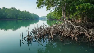
The Sundarbans, a UNESCO World Heritage site spanning India and Bangladesh, is more than just a forest; it is a critical natural shield for millions. Its dense network of mangrove roots acts like a natural concrete wall, absorbing the impact of storm
surges and preventing coastal erosion. This ecosystem is also a massive 'blue carbon' sink, storing vast amounts of carbon that would otherwise contribute to climate change. However, this vital barrier is facing a relentless assault. A combination of rising sea levels, increased frequency of powerful cyclones, and reduced freshwater flow from upstream is causing the coastline to retreat. This gradual land loss threatens not only the unique biodiversity of the region, including the Bengal tiger, but also the lives and livelihoods of the millions who depend on it for protection and resources.
The Eyes in the Sky
Combating this complex problem requires a revolutionary approach. Traditional ground surveys, while important, are slow and difficult in the treacherous, muddy terrain of the Sundarbans. This is where advanced satellite telemetry networks come in. Think of it as a large-scale, remote health monitoring system for the planet. A constellation of satellites, including those operated by ISRO and international partners like NASA, constantly orbits the Earth, equipped with sophisticated sensors. These satellites use technologies like Synthetic Aperture Radar (SAR), which can see through clouds, and multispectral imagers that capture light invisible to the human eye. This allows scientists to gather a torrent of data about the Sundarbans' health day and night, in any weather. The 'telemetry' part simply means this vast amount of data is automatically transmitted from the remote satellites back to research centers on the ground for analysis.
From Data Points to Action Plans
A satellite itself cannot stop a wave, but the information it provides is a powerful weapon for conservation. The core function of these networks is to provide a near real-time, comprehensive picture of the changes happening across the entire delta. By analyzing decades of imagery, scientists can track precisely where the shoreline is eroding and where new land is forming. They use specific indicators, like the Normalised Difference Vegetation Index (NDVI), to measure the health and density of the mangrove canopy, essentially giving the forest a health check-up from space. Areas showing declining plant health or high salinity can be flagged as hotspots needing urgent attention. This transforms conservation from a reactive process to a proactive and highly targeted strategy. Instead of guessing where to intervene, authorities now have a data-driven map guiding their efforts.
Informing On-the-Ground Protection
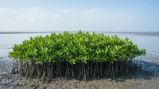
This intelligence from orbit directly empowers on-the-ground protection and restoration efforts. For example, when satellite data identifies a stretch of coastline that is highly vulnerable to erosion, authorities can prioritize it for action. This action could involve 'hard' engineering solutions like building breakwaters or 'soft' nature-based solutions. One of the most effective strategies is targeted mangrove afforestation. Knowing the specific soil salinity and erosion patterns of an area from satellite data helps ecologists choose the right mangrove species for planting, dramatically increasing the success rate of restoration projects. Furthermore, the data helps in creating sophisticated models that predict the path and impact of storm surges, leading to more accurate and timely early warning systems for coastal communities. This is how monitoring translates directly into protection for both the ecosystem and the people.
A Future Built on Synergy
The use of satellite telemetry in the Sundarbans marks a new era of environmental management, where technology and nature work in synergy. Projects like the joint ISRO-NASA mission, NISAR, are set to provide even more detailed and frequent data on ecosystem changes. This continuous stream of information is not just for scientists; it is crucial for policymakers to make informed decisions, for disaster management forces to prepare effectively, and for conservation groups to measure the impact of their work. While the threats of climate change remain immense, this technological alliance provides a crucial advantage. By understanding the intricate dynamics of this precious landscape in unprecedented detail, we stand a better chance of preserving the Sundarbans for generations to come.