



The View From Above: Satellites
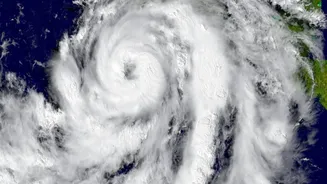
The first step in forecasting rain starts hundreds, or even thousands, of kilometres above Earth. Weather satellites are the sentinels of meteorology, providing a big-picture view of the atmosphere. There are two main types. Geostationary satellites hover
over the same spot on the equator, offering a constant stream of images of an entire hemisphere, making them ideal for tracking large systems like hurricanes. Polar-orbiting satellites fly much closer to the surface, circling from pole to pole to capture highly detailed images of the entire planet. Satellites don't measure rain directly. Instead, their sensors measure electromagnetic radiation. Infrared sensors, for example, detect the temperature of cloud tops; colder, brighter clouds are higher in the atmosphere and have a greater potential to produce heavy rain. Microwave sensors can provide more direct information about water content within clouds. This data gives forecasters the crucial initial overview of where moisture is building and weather systems are forming.
The Ground-Level Truth: Doppler Radar
While satellites provide the broad context, Doppler radar provides the ground truth. Unlike satellites that look down from above, radar stations on the ground send out pulses of microwave energy. When these pulses hit precipitation like raindrops, they bounce back to the receiver. The strength of this returning signal, called 'reflectivity', tells meteorologists about the intensity of the rain. But the 'Doppler' part is the real game-changer. By measuring the frequency shift in the returning signal, the radar can determine the motion of the raindrops—whether they are moving toward or away from the station. This reveals wind patterns inside a storm, helping to identify rotation that could signal severe weather. Radar is exceptional at showing what is happening right now and in the very near future, a process known as 'nowcasting'. It directly detects precipitation, not just clouds, making it an indispensable tool for tracking a storm's movement and intensity at a local level.
The Brains of the Operation: Supercomputers
All this data from satellites, radar, weather balloons, and ground stations would be useless without the ability to process it. This is where supercomputers come in. These machines are the backbone of modern forecasting, capable of performing quadrillions of calculations per second. They run what are known as Numerical Weather Prediction (NWP) models. An NWP model is essentially a digital version of the Earth's atmosphere, represented by a vast three-dimensional grid. Each cell in the grid contains a set of complex mathematical equations based on the laws of physics and fluid dynamics, describing variables like temperature, pressure, wind, and humidity. The supercomputer takes the current weather observations—a process called data assimilation—to set the initial conditions of the model. Then, it solves the equations for each grid cell to predict how the state of the atmosphere will evolve in the next 'time step', repeating this process to build a forecast hours or days into the future.
From Grid to Neighborhood: The Push for Hyperlocal
The incredible processing power of modern supercomputers allows these NWP models to become increasingly granular. The distance between the points on the model's grid determines its resolution. A smaller grid means a higher resolution, allowing the model to simulate weather for a much smaller area—getting closer to that 'exact neighborhood' level. This pursuit of pinpoint accuracy is known as hyperlocal forecasting. By combining global model data with high-resolution radar and other local observations, meteorologists can create forecasts for specific postcodes or even street blocks. Recently, Artificial Intelligence (AI) and machine learning have also begun to play a significant role. AI can be trained on vast amounts of historical weather data to recognize patterns, helping to refine model outputs and improve the speed and accuracy of real-time predictions.
The Final Ingredient: Human Expertise
Despite this incredible technology, forecasting is not fully automated. The final, and perhaps most crucial, element is the human meteorologist. The output from a supercomputer is just guidance, not gospel. A meteorologist's job is to analyze the various model outputs, which can sometimes disagree, and use their expertise to create the most likely forecast. They understand how local geography, like mountains or a coastline, can create microclimates and influence weather in ways a model might miss. They recognize the biases and limitations of certain models and can adjust the forecast accordingly. Systems like the Advanced Weather Information Processing System (AWIPS) bring satellite data, radar, and model outputs into a single graphical interface for forecasters to analyze. Ultimately, it is this synthesis of massive data streams, powerful computation, and expert human judgment that produces the rain forecast you rely on.