






A New Generation of Vision
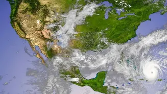
For decades, weather satellites have relied on optical cameras, which work like our own eyes; they can’t see through thick clouds or in the dark. This has always been a major limitation during the monsoon, when cyclones and low-pressure systems are shrouded
in dense cloud cover precisely when we need to see them most. ISRO's latest technological leap forward uses a different approach: Synthetic Aperture Radar, or SAR. This high-tech sensor doesn't just take a picture. Instead, it sends out its own microwave signals towards the Earth and reads the echoes that bounce back. By doing this, SAR can create incredibly detailed images of the ground, day or night, and most importantly, it can penetrate clouds, fog, and smoke. The flagship of this new capability is the recently operational NISAR (NASA-ISRO Synthetic Aperture Radar) satellite, a joint mission that equips India with one of the most advanced Earth observation systems in the world.
Seeing Through the Heart of the Storm
The superiority of SAR for monsoon monitoring lies in this all-weather capability. While a traditional satellite might only see the top of a swirling cloud mass, NISAR can see what’s happening underneath. Its advanced dual-frequency radar system (using both L-band and S-band frequencies) provides a comprehensive view of the landscape. This means ISRO can now track the development of weather systems with unprecedented clarity, even in the midst of a torrential downpour. For instance, it can map the extent of flooding on the ground even when the entire region is blanketed by monsoon clouds. Recent images captured by NISAR during the 2026 Assam floods vividly demonstrated this power, showing the exact spread of the Brahmaputra's waters through cloud cover, providing vital information for rescue and relief efforts. This constant, clear view is a game-changer for real-time disaster monitoring.
From Raw Data to Lifesaving Decisions
This powerful new data stream does more than just create impressive images; it empowers India’s disaster management agencies to make faster, more accurate decisions. With the ability to revisit the same location every 12 days, NISAR builds a continuous record of changes on the ground. This helps meteorologists at the India Meteorological Department (IMD) to more accurately predict a cyclone's path and intensity, allowing for more timely and targeted evacuations. Beyond forecasting, the technology is crucial for response and recovery. After a storm has passed, SAR data can be used to generate rapid and accurate damage assessment maps, highlighting inundated areas, damaged infrastructure, and potential landslide zones. This information is critical for organisations like the National Disaster Response Force (NDRF) to prioritise rescue operations and direct resources where they are needed most.
Strengthening India's Climate Resilience
The deployment of advanced radar sensors is a cornerstone of India's broader strategy to enhance its resilience against climate change and extreme weather events. These high-tech upgrades, part of ISRO's world-class Earth Observation programme, complement other meteorological satellites like the INSAT-3D and INSAT-3DS, which provide continuous weather monitoring. Together, they form a multi-layered surveillance system that protects the nation. The freely available data from missions like NISAR also fuels research into the long-term impacts of climate change, from monitoring glacier melt in the Himalayas to tracking shifts in agricultural patterns. By providing this crucial information, ISRO is not only helping to manage immediate crises but is also contributing to the long-term planning required to safeguard India's environment, economy, and population from future climate-related challenges.