


A New Eye on a Changing Planet
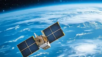
NISAR is a joint mission between NASA and the Indian Space Research Organisation (ISRO), representing a significant partnership in space-based Earth observation. Launched in mid-2025, its primary goal is to make global measurements of the causes and consequences
of land surface changes using advanced radar imaging. Unlike optical satellites that are hindered by clouds or darkness, NISAR uses dual-frequency Synthetic Aperture Radar (SAR) to provide consistent, high-resolution data day or night, in any weather. This capability is crucial for systematically monitoring our dynamic planet, from the slow creep of tectonic plates to the rapid retreat of glaciers.
Seeing Through Clouds and Darkness
Synthetic Aperture Radar is a powerful remote sensing technology that sends microwave signals to the Earth's surface and interprets the signals that bounce back. By doing this, it can measure tiny changes in the planet's surface with centimetre-level precision. The NISAR mission is the first to use two different radar frequencies, L-band and S-band, which allows it to observe a wide range of phenomena. This includes tracking shifts in ecosystems, monitoring ice sheet collapse, and providing critical data on natural hazards like earthquakes, volcanoes, and landslides. For a country like India, which faces a multitude of climate-related risks, this all-weather capability is a game-changer for disaster management and environmental monitoring.
A Flood of Freely Available Data
One of the most groundbreaking aspects of the NISAR mission is its data policy: all science data is freely and openly available to the public. Starting in July 2026, calibrated L-band data became accessible through NASA's data portals, with ISRO hosting the S-band data on its Bhoonidhi platform. This marks a shift from data scarcity to data abundance. The satellite will scan the entire globe every 12 days, generating an enormous volume of information. This deluge of high-quality, analysis-ready data empowers researchers, startups, and government agencies to tackle complex problems without the prohibitive cost often associated with satellite imagery.
The Urgent Need for Data Literacy
However, this massive data release comes with a significant challenge. Raw radar data is not like a simple photograph; it is complex and requires specialized knowledge to process and interpret. Techniques like interferometry (comparing two radar images to detect surface movement) and polarimetry require specific skills and software. Without a trained workforce, the petabytes of data from NISAR risk becoming an underutilised asset. Recognizing this gap, NASA and other organizations have already started offering training courses designed to help users understand, access, and analyze NISAR data for various applications like flood detection and landslide risk assessment. This highlights the central point: the availability of data is only the first step. Building human capacity is the next, more critical one.
Unlocking India’s Climate Resilience
For India, the applications are immense and directly tied to national priorities. ISRO has identified key areas where NISAR data will be vital, including monitoring agricultural biomass to ensure food security, studying Himalayan snow and glaciers to manage water resources, and improving disaster response. The data can help create more accurate flood inundation maps, identify areas at risk of subsidence from groundwater extraction, and monitor deforestation with unprecedented accuracy. To turn this potential into reality, an ecosystem of skilled analysts, data scientists, and geospatial professionals is needed. This creates a significant opportunity for universities, technical institutes, and private ed-tech platforms in India to develop specialised curricula focused on SAR data analysis.