







A New Vantage Point in the Sky
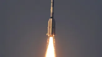
On September 4, 2026, the Indian Space Research Organisation (ISRO) successfully launched its EOS-05 satellite aboard a GSLV-F17 rocket from Sriharikota. What makes this mission particularly noteworthy is its destination: a geosynchronous orbit approximately
36,000 kilometres above Earth. Unlike satellites in low-Earth orbit that pass over locations intermittently, a satellite in a geosynchronous orbit moves at the same speed as the Earth's rotation. This allows it to remain over the same broad geographical area, providing the capability for near-continuous observation of the Indian subcontinent and its surrounding regions. This successful launch is a major achievement, especially following the unsuccessful EOS-03 mission in 2021 which failed due to a cryogenic stage anomaly.
Advanced Eyes for a Changing Nation
EOS-05 is not just about its high altitude; it's about the sophisticated technology it carries. The satellite is equipped with powerful imaging instruments designed for a wide range of civilian and strategic applications. These instruments can capture high-resolution images that will be crucial for everything from urban planning and infrastructure development to border surveillance. This constant watchfulness provides a stream of data that can be used to track changes on the ground in near real-time, a significant leap forward from previous capabilities. This mission represents a key step in ISRO's broader goal of creating a comprehensive Earth Observation System that serves India's diverse developmental and security needs.
A Shield Against Natural Disasters
One of the most critical applications of advanced Earth observation is disaster management, an area where India is particularly vulnerable to events like cyclones, floods, and landslides. With its ability to provide repeated imaging, EOS-05 will greatly enhance the country's ability to monitor severe weather events as they develop. Satellites like this are instrumental in tracking cyclone formation and intensification, mapping flood-affected areas, and identifying regions at risk of landslides. This near real-time information flow is vital for providing early warnings to communities, enabling timely evacuation, and coordinating effective response and relief efforts on the ground, ultimately saving lives and property.
Transforming Agriculture and Resource Management
Beyond disaster response, the data from ISRO's Earth observation satellites has a profound impact on agriculture, the backbone of the Indian economy. By monitoring factors like soil moisture, crop health, and vegetation cover, these satellites provide invaluable insights for farmers and policymakers. The information helps in predicting crop yields, managing water resources more efficiently, and implementing precision agriculture techniques that can boost productivity and sustainability. Furthermore, the capabilities of satellites like the recent Oceansat-3 (EOS-06) and the upcoming NASA-ISRO Synthetic Aperture Radar (NISAR) mission demonstrate a focus on monitoring oceans, land vegetation, and soil moisture with incredible detail, helping to manage everything from marine resources to forest cover.
A Strategic Asset for the Future
The continuous enhancement of its Earth observation capabilities is a cornerstone of India's strategic autonomy. Having a robust, indigenous network of satellites ensures that the nation does not have to depend on foreign agencies for critical geospatial data. This self-reliance is vital for national security, environmental monitoring, and achieving sustainable development goals. Missions like EOS-05 and the collaborative NISAR project, which will be the first satellite to use two different radar frequencies to measure changes in our planet's surface, position India as a formidable player in the global space arena. These 'eyes in the sky' are more than just technological marvels; they are essential tools for governing a dynamic and developing nation, securing its resources, and protecting its people.