





The Gathering Storm: What is Cyclone Akvan?
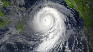
Cyclone Akvan began as a low-pressure area over the Bay of Bengal and rapidly intensified, becoming a cyclonic storm on November 16. As of the morning of November 18, the India Meteorological Department (IMD) has confirmed its intensification into a Severe
Cyclonic Storm located over the west-central Bay of Bengal. The name 'Akvan' was contributed by Iran as part of the rotating list maintained by 13 member countries for the North Indian Ocean region. These names are used to help identify storms and communicate warnings more effectively to the public and disaster management agencies. The storm has been moving slowly in a north-northwesterly direction, a characteristic that allows it to gather more strength from the warm sea waters.
IMD's Forecast: Path and Intensity
The IMD is projecting a serious threat to the Indian coast. The forecast indicates that Akvan will likely strengthen further into a Very Severe Cyclonic Storm by the evening of November 19. The current track predicts the storm will make landfall on November 20, around noon. The expected landfall location is along the Andhra Pradesh coast, somewhere between Nellore and Visakhapatnam, also affecting the Yanam region. At the time of crossing the coast, the IMD anticipates maximum sustained wind speeds of 120-130 kmph, with gusts potentially reaching up to 145 kmph.
Which States Are on High Alert?
Andhra Pradesh is facing the most direct threat, with the state government already placing coastal districts on high alert and reviewing preparedness measures. Chief Minister N. Chandrababu Naidu has reviewed the situation, focusing on the return of fishing boats from the sea. Heavy to extremely heavy rainfall is predicted for coastal Andhra Pradesh. The impact is not limited to one state. Neighbouring Odisha has also geared up for potential impact, deploying rescue teams and identifying landslide-prone villages for possible evacuation. The storm's outer bands are also expected to bring significant rainfall to parts of Telangana and West Bengal between November 19 and 21.
Decoding the IMD's Warnings
The IMD uses a colour-coded system to communicate the severity of weather events. An 'Orange Message' or alert, which has been issued for the Andhra Pradesh and adjoining south Odisha coasts, signifies a 'Be Prepared' warning. This indicates that extremely bad weather is expected, with the potential for travel disruptions and a threat to life and property. As the storm approaches landfall, this could be upgraded to a 'Red' alert, which means 'Take Action'. For the general public, these warnings are a signal to secure their homes, prepare emergency kits, and be ready for potential evacuation orders from local authorities. Fishermen have been strictly advised to avoid venturing into the Bay of Bengal.
Why the Bay of Bengal is a Cyclone Hotbed
The Bay of Bengal is a particularly active region for tropical cyclones, especially during the post-monsoon season (October to December). The bay's warm, shallow waters provide the necessary heat and moisture that act as fuel for these massive weather systems. The shape of the coastline also contributes to the danger, as the funnel-like geography can amplify storm surges, leading to extensive coastal flooding. A storm surge is an abnormal rise in sea level caused by the cyclone's powerful winds and low pressure, and it is often the most destructive aspect of a cyclone's impact, capable of inundating low-lying coastal areas.