





Our Guardians in the Sky
India’s capability in weather forecasting and disaster management is powered by a sophisticated network of satellites built and operated by the Indian Space Research Organisation (ISRO). These aren't just single satellites, but entire families of them
working in concert. The most prominent are the INSAT (Indian National Satellite System) series, which are geostationary satellites. Think of them as being parked in a fixed spot above the Earth, allowing them to continuously monitor the Indian subcontinent. Satellites like INSAT-3D and INSAT-3DR are specifically designed for meteorology, equipped with imagers to see cloud patterns and sounders to measure temperature and humidity in the atmosphere. This constant stream of data is the first step in predicting weather phenomena, from daily rain to devastating cyclones.
Seeing Through Clouds and Darkness
But what happens when it’s cloudy, especially during the monsoon when flood risk is highest? This is where the RISAT (Radar Imaging Satellite) series comes in. Unlike optical satellites that need clear skies and daylight, RISAT satellites use Synthetic Aperture Radar (SAR). They actively send down microwave signals and analyse the echoes that bounce back, allowing them to “see” the Earth’s surface regardless of cloud cover or time of day. This all-weather capability is a game-changer for disaster management. During heavy rains, RISAT can precisely map the extent of flooding in river basins like the Ganga and Brahmaputra, providing invaluable information for rescue and relief operations even when the area is completely obscured by clouds.
The Journey from Data to Warning
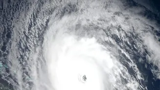
Collecting data is only half the battle. This raw information from space is beamed down to ground stations where specialised agencies take over. The India Meteorological Department (IMD) is the key player here. At their processing centres, data from INSAT satellites on cloud formation, sea surface temperature, and wind vectors are fed into powerful numerical models. These models help meteorologists forecast the formation, intensity, and path of cyclones. In fact, this satellite-driven system has drastically improved the accuracy and lead time of cyclone warnings. For example, during Cyclone Fani, five different ISRO satellites provided data every 15 minutes, allowing for precise tracking and enabling the timely evacuation of over a million people.
Coordinating the Response on the Ground
Once a forecast or a disaster map is ready, getting that information to the right people is critical. ISRO’s data is channelled through portals like Bhuvan and the National Database for Emergency Management (NDEM) to various agencies. The National Disaster Management Authority (NDMA) and State Disaster Management Authorities use these inputs to plan their response. Flood inundation maps created from RISAT data help rescue teams identify which villages are cut off and where to direct resources. Satellite communication systems also play a vital role, providing connectivity for emergency services in areas where terrestrial networks have been damaged by a disaster. This seamless coordination, from a satellite detecting a low-pressure system over the ocean to a rescue worker getting an alert, is what ultimately helps mitigate the impact of natural calamities.