



A Paradise Under Pressure
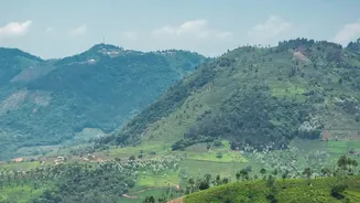
Stretching parallel to India's western coast, the Western Ghats are a global biodiversity hotspot, older than the Himalayas themselves. This incredible mountain chain dictates weather patterns, influences the monsoon, and feeds the rivers that sustain
millions. It is home to thousands of plant and animal species found nowhere else on Earth. But this natural treasure is in trouble. A combination of climate change, deforestation, and relentless human activity has pushed the region’s delicate ecosystems to a tipping point. More frequent and intense rainfall, unchecked construction, quarrying, and the expansion of plantations have led to a cascade of crises, from habitat loss to devastating landslides.
India's First 'Red List' for Ecosystems
In response to the growing crisis, the Kerala State Biodiversity Board (KSBB) launched a groundbreaking initiative in October 2026: India's first Red List Assessment of Ecosystems. Think of it like the famous Red List for endangered species, but for entire habitats. Led by the Kerala Forest Research Institute and other partners, this year-long project is a race against time to scientifically evaluate the risk of ecosystem collapse across all of Kerala's 14 districts, from the highest mountain peaks to the coastal plains. This moves conservation beyond focusing on a single species to protecting the interconnected systems that support all life.
How the Mapping Works
The project uses the International Union for Conservation of Nature (IUCN) framework, a globally recognised standard. Researchers will analyse factors like historical habitat loss, the degree of fragmentation, and disruptions to water systems. For example, some tropical riparian forests along rivers in the southern Western Ghats have already lost over 80% of their original area in the last century. By combining satellite data, on-the-ground surveys, and computer modelling, scientists can create detailed maps that identify which ecosystems are 'Vulnerable', 'Endangered', or 'Critically Endangered'. The goal is to produce an official Risk Register and an Ecosystem Typology Atlas that can be used by planners and local governments.
From Data to Disaster Prevention
This mapping is not just an academic exercise. Its primary goal is to save lives and secure the future. The data will inform land-use planning, helping authorities decide where it is unsafe to build and which areas must be preserved. For a state frequently hit by catastrophic landslides, this kind of micro-level hazard mapping is crucial. Another key aspect involves integrating traditional knowledge with modern science. The Kerala State Disaster Management Authority (KSDMA) has already piloted community-led disaster management plans in vulnerable tribal hamlets, recognising that local populations often possess invaluable knowledge for managing climate risks. The findings from the Red List project will empower these local Biodiversity Management Committees to make informed decisions.
A Blueprint for the Future
The long-standing debate over how to protect the Western Ghats, crystallised in the recommendations of the Gadgil and Kasturirangan committee reports, highlights the deep conflict between development and conservation. These reports flagged many of today's high-risk zones years ago, but their implementation has been fraught with political challenges. The new Red List project offers a fresh, science-driven path forward. By creating an objective, data-backed baseline of ecosystem health, it provides a powerful tool to guide sustainable development. It’s an attempt to break the cycle of inaction by providing clear, undeniable evidence of the risks and identifying priority areas for restoration before they are lost forever.