









The Forecast for Cyclone Akvan
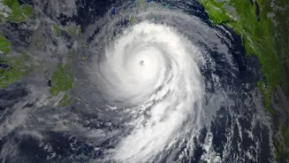
A weather system developing over the ocean has the potential to intensify into a cyclonic storm. If this happens, it will be named 'Akvan', a name contributed by Iran to the rotating list used for cyclones in the North Indian Ocean. The India Meteorological
Department (IMD), as the Regional Specialised Meteorological Centre, is responsible for monitoring this system. It will only be officially named Akvan once it reaches a sustained wind speed of at least 62 kilometres per hour. Until then, it is classified as a depression or deep depression. The IMD is tracking its potential path and intensity, and will issue formal bulletins as it evolves. Forecasts can change, so it's vital to follow the latest official updates and not rely on early, speculative information.
Why the IMD is Your Only Trusted Source
During cyclone season, social media and messaging apps often flood with unverified maps, graphics, and alarming predictions from self-proclaimed experts. This misinformation can cause widespread panic, leading to dangerous actions like premature crop harvesting or confusion over evacuation orders. The Odisha government has even issued warnings about the legal consequences of spreading such false alarms, which can be punishable under the Disaster Management Act. The IMD is the sole agency mandated by the Government of India and the World Meteorological Organization (WMO) to issue cyclone warnings for the region. With a history dating back to 1875, it uses a sophisticated network of satellites, Doppler radars, and advanced numerical models to provide the most accurate forecasts possible. Relying on the IMD's official channels ensures you get verified, actionable information, not fear and confusion.
How to Read an IMD Cyclone Bulletin
IMD bulletins can seem technical, but they contain crucial details. They are issued every few hours during a storm. Key information includes the cyclone's current position (latitude, longitude, and distance from a known coastal town), its intensity category (e.g., Severe Cyclonic Storm), and its forecast track and speed. The bulletin will specify the expected time and location of landfall and the anticipated maximum wind speeds. It’s important to look for the 'cone of uncertainty' on forecast maps; this cone shows the probable path of the storm's centre, not the size of the entire storm. Destructive winds and heavy rain can extend hundreds of kilometres from the centre. Always check you are reading the very latest bulletin, as storm paths can change.
Understanding the Four-Stage Warning System
The IMD uses a clear, four-stage warning system to help authorities and the public prepare systematically. The first is the 'Pre-Cyclone Watch', issued 72 hours in advance, which is an initial alert about a developing system. This is followed by the 'Cyclone Alert' (Yellow message), issued 48 hours before, advising people to stay updated and for fishermen to return from sea. The 'Cyclone Warning' (Orange message) comes 24 hours before landfall, giving specific details on location, wind speed, and expected damage, triggering preparedness measures. Finally, the 'Post-Landfall Outlook' (Red message) is issued about 12 hours before the cyclone crosses the coast, detailing its likely movement and impact inland after landfall.
Decoding the Colour Codes: From Yellow to Red
To simplify communication, the IMD uses a colour-coded alert system. Green indicates 'No Warning'. A Yellow alert means 'Be Updated'; it signals the possibility of bad weather and asks people to monitor the situation. An Orange alert means 'Be Prepared'; it signifies that extremely bad weather is expected, which could disrupt power and transport, and authorities begin to mobilise resources. The highest level is a Red alert, which means 'Take Action'. This is issued when extremely severe weather is imminent, posing a significant risk to life and property. A Red alert triggers mass evacuation procedures and the complete suspension of activities in the affected zone.