




The Challenge of the Open Sea
For centuries, the arrival of the monsoon has been a subject of anticipation and anxiety. Its rains are the lifeblood of Indian agriculture, but the cyclones and low-pressure systems that form far from shore can unleash devastating winds and floods with
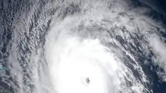
little warning. Traditional weather forecasting, reliant on ground stations and optical satellites, faces a significant hurdle: clouds. Dense, towering monsoon clouds can obscure the developing structure of a storm, making it difficult to accurately predict its intensity and path. This is especially true over the ocean, where there are no ground-based instruments. Predicting a storm's behaviour before it nears the coast has long been one of meteorology's greatest challenges.
ISRO’s All-Weather Eyes
This is where the Indian Space Research Organisation (ISRO) steps in, armed with a technology that doesn't need clear skies: Synthetic Aperture Radar (SAR). Unlike optical satellites that work like a camera and need light, SAR is an active system. It sends out its own microwave signals towards the Earth's surface and reads the echoes that bounce back. Because microwaves can penetrate clouds, haze, and darkness, SAR satellites can provide clear images of the ocean and storm systems at any time of day and in any weather. ISRO's series of Radar Imaging Satellites (RISAT) are the workhorses of this effort, providing crucial data for disaster management and weather surveillance.
The Power of High Resolution
Recent upgrades and new missions have significantly boosted these capabilities. The key advancement is in 'high resolution.' Think of it as upgrading your television from a blurry, standard-definition screen to a sharp 4K display. Higher resolution allows ISRO's satellites to see finer details within a storm system. Instead of just a large, rotating mass, scientists can discern the structure of the eyewall, the organisation of rainbands, and even the roughness of the sea surface, which indicates wind speed. The joint NASA-ISRO mission, NISAR, which entered its science phase in 2026, is a game-changer. It is the first satellite to use two different radar frequencies (L-band and S-band), allowing it to capture an incredibly wide 240-km strip of Earth with remarkable detail, revisiting the same spot every 12 days.
From Satellite Data to Public Warning
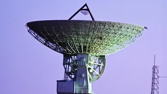
Capturing an image is just the first step. Once a satellite like RISAT-1A or NISAR collects the data, it is beamed down to ISRO's ground stations. Scientists at centres like the National Remote Sensing Centre (NRSC) in Hyderabad and the Space Applications Centre (SAC) in Ahmedabad process this raw information. They turn complex radar backscatter data into understandable maps of wind speed, wave height, and storm structure. This processed intelligence is then shared with the India Meteorological Department (IMD). The IMD combines the satellite data with information from its own network of Doppler Weather Radars and ground stations to issue precise, timely warnings. These alerts, which can pinpoint the likely location and time of landfall, are then disseminated to disaster management agencies, state governments, and the public.
Saving Lives and Livelihoods
The impact of this technology is profound. Accurate, early warnings give coastal communities precious time to evacuate, saving countless lives. Fishermen receive alerts not to venture out to sea, protecting their livelihoods and their lives. The data also aids in broader resource management. For instance, NISAR's capabilities are used for monitoring everything from soil moisture for agriculture to the stability of coastlines and the movement of glaciers. By providing a reliable, all-weather view of our planet's most powerful weather systems, ISRO's radar satellites have become an indispensable tool in India's efforts to build climate resilience and safeguard its citizens from the raw power of the monsoon.