


A Promising Start, A Sudden Stop
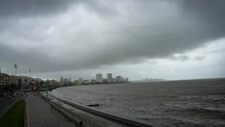
It all began so well. The Southwest Monsoon arrived over Kerala two days ahead of schedule on May 30 and made rapid progress, covering large parts of Maharashtra, Karnataka, and Telangana with satisfying speed. The early and vigorous onset brought much-needed
relief from the scorching pre-monsoon heat, raising hopes for a timely and well-distributed rainy season across the country. However, after its initial burst of energy, the monsoon's northern limit has remained stubbornly static for over a week. The India Meteorological Department (IMD) has confirmed this lull, noting that the advance has stalled over key regions, including parts of Maharashtra, Chhattisgarh, and Odisha, delaying its much-anticipated arrival in northern and central India. This pause has left many wondering what went wrong after such a powerful start.
The Primary Culprit: Weakened Currents
At its core, the monsoon is a massive sea-breeze system driven by wind currents. Its advance relies on strong, moisture-laden westerly winds blowing from the Arabian Sea onto the Indian subcontinent. Currently, these crucial cross-equatorial flows have become weak. Without a strong and sustained push from these winds, the monsoon system loses its momentum and is unable to advance further north. This weakening isn't an arbitrary event; it’s influenced by larger atmospheric patterns. Think of it like a car running out of fuel. The engine (the monsoon) is still there, but the fuel supply (strong winds) has been temporarily cut off, bringing its journey to a halt. This is the most direct reason for the current stagnation.
The Role of the Anticyclone Barrier
Compounding the problem of weak winds is the presence of an "anticyclone." An anticyclonic circulation is a large-scale circulation of winds around a central region of high atmospheric pressure. In the Northern Hemisphere, these winds flow in a clockwise direction. Currently, an anticyclone has established itself over parts of the Arabian Sea and the west-central Bay of Bengal. This high-pressure system acts like a giant atmospheric wall. It suppresses cloud formation and rainfall activity. More importantly, its clockwise winds actively work against the moisture-laden westerlies, effectively blocking their path and preventing them from pushing the monsoon system further inland. Until this anticyclone weakens or moves away, the monsoon's northern advance will remain significantly hampered.
An Unfavourable Global Influence: The MJO
The monsoon's behaviour is also influenced by larger, planet-circling weather patterns. One of the most significant is the Madden-Julian Oscillation (MJO). The MJO is a massive pulse of rain and thunderstorms that travels eastward around the tropics, completing a full circuit in 30 to 60 days. When the MJO is in a favourable phase over the Indian Ocean, it enhances monsoon activity. Conversely, when it is in an unfavourable phase, it can suppress rainfall and weaken monsoon currents. According to meteorological reports, the MJO is currently not in a position that favours the Indian monsoon. This global factor is contributing to the overall weakness of the system, creating conditions ripe for a pause or a "weak monsoon" phase.
What Happens Now on the Ground?
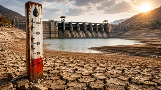
The immediate consequence of this pause is a return of uncomfortable weather conditions. In the regions where the monsoon has stalled, temperatures are rising again, coupled with high humidity, creating a "break monsoon" condition that feels intensely sultry and oppressive. For farmers, this delay is a source of major anxiety. Sowing of crucial Kharif crops like paddy, soybean, and cotton is timed with the monsoon's arrival. A prolonged delay can disrupt the agricultural calendar, potentially affecting crop yields and the rural economy. Water reservoirs, which were hoping for a quick refill, will also have to wait longer. The delay means that states in North India, including Delhi, Punjab, and Haryana, will continue to experience heatwave conditions for longer than initially anticipated.
When Will the Monsoon Revive?
The good news is that meteorologists widely agree that this is a temporary phase. The IMD and other weather agencies are forecasting a revival of the monsoon's advance soon. Favourable conditions are expected to develop around the third week of June. The anticyclone is predicted to weaken, and the crucial westerly winds are expected to regain their strength, allowing the monsoon to once again push northwards into central and northern India. While pauses like this can be frustrating, they are not entirely uncommon. The monsoon is a complex and dynamic system, and its journey is rarely a smooth, uninterrupted march across the subcontinent. These lulls are a natural part of its rhythm.