A Groundbreaking India-US Partnership
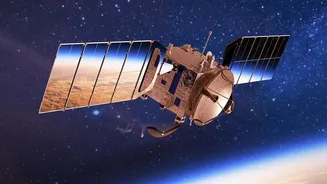
At its core, the NASA-ISRO Synthetic Aperture Radar (NISAR) mission is a powerful symbol of international collaboration. It is the first satellite mission to bring together two different radar frequencies—the L-band, built by NASA, and the S-band, developed
by ISRO—to systematically map our planet. This dual-frequency approach allows for an unprecedentedly detailed and comprehensive view of Earth’s surface, measuring changes down to a centimetre. Launched from the Satish Dhawan Space Centre in India, the mission is a testament to the shared scientific goals of both nations, aimed at tackling some of the most pressing environmental challenges of our time.
Seeing the Unseen with SAR
What makes NISAR so revolutionary is its use of Synthetic Aperture Radar (SAR). Unlike traditional optical satellites that are essentially cameras in space, SAR is an active sensor. It sends microwave pulses to the Earth's surface and measures the returning echoes to create an image. This technology has two huge advantages: it can see through clouds and operate day or night, providing a consistent stream of data regardless of weather or light conditions. The 'synthetic' part comes from using the satellite's motion to simulate a much larger antenna, which allows for incredibly high-resolution images from a compact instrument. NISAR's L-band can even penetrate through forest canopies, giving scientists a view of what's happening on the ground below.
The Power of an Open Data Policy
Perhaps the most significant aspect of the NISAR mission is its commitment to a free and open data policy. All data from both the L-band and S-band instruments are being made available to the public, scientists, and institutions around the world without charge. ISRO's S-band data is available via its Bhoonidhi portal, while NASA's L-band data is accessible through the Alaska Satellite Facility. This democratic approach is designed to accelerate scientific discovery. By removing barriers to access, researchers globally can collaborate, develop new applications, and find innovative solutions to local and global problems. For India, ISRO has established the NISAR Utilization Programme (NISAR-UP) to encourage and fund domestic researchers in using this rich dataset.
Transforming Lives and Policy in India
The applications for NISAR data are vast and particularly relevant for India. ISRO has identified key areas where the satellite will provide critical insights. For agriculture, the data will help monitor crop health, assess soil moisture, and support food security objectives. In the Himalayas, it will track snow and glacier melt, providing crucial information for water resource management and understanding climate change impacts. Its ability to detect subtle ground deformation will revolutionize disaster management, offering early warnings for landslides and a better understanding of earthquake-prone zones. Following natural disasters, NISAR can provide rapid-response imagery to aid relief efforts, a service that will save lives and resources.
A Flood of Data for a Changing World
The scale of data from NISAR is immense, expected to generate nearly 85 terabytes per day—a volume that dwarfs previous Earth observation missions. This deluge of information will provide a time-lapse view of Earth, with the satellite imaging the entire planet twice every 12 days. This consistent and frequent coverage is key to building a long-term record of change, from the slow creep of a subsiding city to the rapid retreat of a glacier. The provisional data released in July 2026 is just the beginning, with the full, validated science record expected to be available by the end of the year, opening up new frontiers in our ability to monitor and protect our home.