


Start Before You Book
Smart travel planning begins long before you book your tickets or accommodation. The first step is to understand the seasonal risks of your chosen destination. India's monsoon season, while transforming landscapes into lush paradises, also brings the risk of heavy
rains, flooding, and landslides, particularly in hilly regions and coastal areas. Start by researching the typical weather patterns for your destination during your intended travel dates. Government resources can provide historical data on flood-prone zones. The Central Water Commission (CWC) and the National Disaster Management Authority (NDMA) offer extensive information and maps that can help you assess long-term risks. Choosing destinations that are less affected by heavy rains during this season can be a wise move, but even in popular spots, a little pre-booking research goes a long way in ensuring a safer, more relaxed holiday.
Your Digital Toolkit for Safety
Once your trip is booked, it's time to assemble your digital safety toolkit. Technology has made it easier than ever to stay informed in real-time. The Central Water Commission is a key agency for flood forecasting in India, issuing thousands of forecasts annually with high accuracy. Before you leave, bookmark the CWC's flood forecast portal on your phone. Download official apps like the India Meteorological Department's (IMD) 'Mausam' for weather updates and the CWC's 'FloodWatch India' app, which provides real-time flood situation updates for hundreds of stations across the country. Additionally, the NDMA is actively testing a 'Cell Broadcast Alert System' to send critical warnings directly to mobile phones in affected areas, a system known as SACHET. Having these resources at your fingertips is like having a digital guardian angel for your trip.
Decoding the Alerts
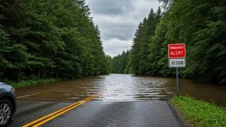
Receiving an alert is one thing; understanding what it means is another. The CWC uses a clear, colour-coded system to classify flood situations, which helps in quickly assessing the severity. A 'Yellow' alert signifies an 'Above Normal' flood situation, where the river level has crossed the warning mark but is still below the danger level. An 'Orange' bulletin indicates a 'Severe Flood' situation, where the water has crossed the danger level. This triggers more frequent updates. The most critical is a 'Red' bulletin, for an 'Extreme Flood' situation, when the water level has surpassed the highest recorded flood level. Understanding these distinctions allows you to react appropriately—whether it means exercising extra caution, changing your route, or preparing for a potential evacuation. Don't ignore these alerts; they are designed to give you crucial time to act.
On-the-Ground Intelligence
While official apps and websites are invaluable, they should be supplemented with on-the-ground intelligence. Your best resources are often the local people who live and work in the area. Talk to your hotel staff, tour guides, and drivers about the local conditions. They possess a wealth of knowledge about which roads are safe, which areas are prone to waterlogging, and what the typical signs of trouble are. Be flexible with your itinerary. Heavy rainfall can cause sudden disruptions like landslides or road closures, especially in the hills. It's crucial to have a backup plan and to avoid travelling through flooded areas. The depth and current of floodwater can be deceptive and dangerous. If local authorities issue an advisory, follow it without question. Their primary goal is to ensure public safety.