






The View From Space
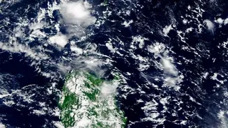
Recent satellite imagery has sparked conversations across the country, showing a dramatically different India from the cloud-heavy maps of July and August. Vast stretches, particularly over northwest and central India, are now visibly clear, a tell-tale
sign that the vigorous monsoon system is losing its punch. While these images are striking and point to weakening monsoon activity, meteorologists are quick to clarify that this doesn't automatically signal an official withdrawal. The India Meteorological Department (IMD) has a specific set of criteria that must be met before any formal declaration. So while the visual evidence from space is a powerful indicator of change, it's just one part of a much larger atmospheric story.
The Three Key Signals for Withdrawal
The IMD doesn't just look at a clear sky to call time on the monsoon; it's a rigorous, data-driven process. There are three main conditions that must be satisfied, especially for the initial withdrawal from the country's northwestern regions. First, there must be a cessation of rainfall over the area for five consecutive days. Second, and crucially, an 'anticyclone' needs to establish itself in the lower atmosphere. This is a large-scale circulation of winds around a central region of high atmospheric pressure, which pushes moisture-laden clouds away. Third, there must be a significant reduction in moisture, something that is measured using satellite water vapour imagery and other tools. Only when all three of these conditions align does the official retreat begin.
So, Has It Started?
As of early September 2026, the official withdrawal has not yet begun, but the conditions are becoming favourable. While some areas have seen reduced rainfall, active weather systems have persisted in others, including parts of North and Central India. Weather models from global agencies project that the crucial anticyclonic circulation will gradually strengthen over northwest India through the second half of the month, likely maturing around September 21. The formal withdrawal process typically doesn't start before September 1st and begins from West Rajasthan, progressively moving southeast across the country over several weeks. Forecasts currently suggest that the formal process will begin after September 15th this year.
An Erratic Season to the End
This year's monsoon has been characterized by its erratic nature, with prolonged dry spells punctuated by intense downpours, leading to a nationwide rainfall deficit as of early September. The 2026 monsoon began under the shadow of a developing El Niño, a climate pattern often associated with weaker monsoon rainfall in India. This uneven distribution has created a complex situation on the ground, with some regions facing floods while large parts of the south remain dry. This variability makes the timing of the withdrawal even more critical. A timely retreat is needed to allow for the harvesting of summer-sown crops, while sufficient late-season rain is vital for ensuring adequate moisture in the soil for planting winter crops like wheat and chickpeas.